Ouse or Hundred Foot Washes
Features and Structures
Introduction
Each section of this page shows in tabular form brief details of the features and structures of the Washes including those described on the History & Management page operation section.The tables also act as an addtional site index with links to detailed pages and photos of each item. There are hundred of photos on the site, old and new, and some slideshows too, which, apart from the sampler below, can run automatically or be completely manually controlled.
|
If this message remains displayed, your computer's settings need attention or you may need to "allow blocked content". |
|
Scroll down to or choose a subject from the index. To open: press firmly and hold, then tap a subject; or hover mouse. You can return to the index anytime via button on left.
- Index/Contents of this page
- top of page
- Introduction
- Rivers, Drains & Canals
- River banks, 'Barrier banks',
- Washlands
- Floodwater storage (reservoir)
- Extra floodwater storage areas
- Cross sections across washes
- Pumping Stations data table
- Sluices, Locks, Weirs & Dams
- Roads, Bridges & Causeways
- Ferries
- Railway - a guided slideshow
- Slackers & Irrigation inlets
- Water Levels & Gauge Boards
- Pubs & Inns
- Houses, Dwellings
- Wartime Installations
- Cattle Pens
- Nature Reserves, Visitor Centres
- New Bird & Wildlife Habitats
- Main pages of this site
- Home page & site index original page
- Overview: history & management
- Features: natural & man-made
- Site Index & Contents: A-Z
- Related pages on other sites
- Prickwillow steam eng. museum
- Stretham Old Engine
Rivers
Everything about the rivers or drains in and around The Washes is confusing - please read this section in conjunction with a section of my 'Overview' page riversThose in the first two tables below are the "high-level" man-made watercourses which run above the surrounding land through raised embankments. They are known as "main rivers" and are managed by large organisations - since 1996 by the Environment Agency (EA) - responsible for discharging the waters into the sea.
Many man-made watercourses were named by the width in feet of the top of the cut. Consequently "Twenty Foot" , "Thirty Foot" etc are common names throughout the fens. (If a drain has been widened, or fallen into disrepair the current width often bears no resemblence to the original. Thus the Sixteen Foot is much wider than the Forty Foot.) Also confusing is that the names Counter Drain and Delph refer to their purpose (cut parallel to another drain) and appear elsewhere in the fens
Smaller watercourses draining low-level local areas (called 'districts') are not shown. Each district is managed by a group of local farmers and landowners known as an Inland Drainage Board (IDB) or Drainage Commission (DC). The IDBs/DCs pump their excess water up into the main rivers and pay a levy to the EA for doing so. (Districts are much later divisions of Vermuyden's original 'levels'.)
Table 1 - Mid 17th C after creation of the Hundred Foot Washes (Ouse Washes)
| Name and alternative(s)1 | abbr | from | to | cut | |
| Seventy Foot River (Bedford River) (renamed Old Bedford River 1652)2 |
BR, OBR | Earith, west side of Washes | (Old) Bedford Sluice at Salters Lode | 1637 | non-tidal |
| Old Bedford River2 (joined with the 40 Foot River) |
OBR | Welches Dam | (Old) Bedford Sluice at Salters Lode | 1652 | non-tidal |
| Hundred Foot Drain
(or River) (aka New Bedford River) |
NBR | Earith, east side of Washes | adjacent to Denver Sluice | 1652 | Tidal |
| 1 | The names of the rivers can be very confusing, not just by being named by width as explained above. The order of alternatives shown above does not necessarily indicate the correct or most commonly used ones. |
| 2 | The OBR was dammed c1652 at what became known as Welches Dam. The southern section was abandoned; the Forty Foot River was joined via a lock to the northern section which continued to Salters Lode. The two parts of the Old Bedford later became two completely separate river systems (see below) compounding the confusion. |
Table 2 - Mid 18th C to date
| Name | abbr | from | to | cut | |
| Counter Drain/Old Bedford River1 | CD/OBR | Colne & Somersham | Old Bedford Lock/sluice at Salters Lode | nth 1632-7 sth 1652 |
non-tidal |
| Old Bedford/Delph River2 | OB/DR | Earith Sluice | Welmore Lake Sluice | nth 17503 sth 1632-7 |
non-tidal |
| New Bedford River (Hundred Foot River)5 |
NBR | Earith | adjacent Denver Sluice | 1652 | Tidal |
| 1 | This river system combines the Cranbrook Drain from the "highlands" around Colne and Somersham to Black Sluice (BS) just north of Earith where it joins the start ('head') of the Counter Drain (CD), which runs to the west of and parallel to the Old Bedford River (OBR) to Welches Dam (WD) where it is joined to the northern section of the original OBR. |
| 2 | This river system combines the southern section of the original OBR from Earith Sluice to WD where it is joined to a newer cut, the River Delph, dug c1750 (or 1772?) from WD to the NBR at Welmore Lake. |
| 3 | Most historians say the date the Delph was cut is not known, but presume c1750 but see note 4 |
| 4 | The year 1772 is quoted by N. James in "Drowned and Drained" a Cambridge University publication in 2009, but no source attributed. |
| 5 | Vermuyden had the bed set 8ft (2,5m) higher than that of the Great Ouse at Denver. This resulted in the flow of the NBR being turned southeast at Denver by incoming tides inundating the South Level instead of going north to the sea. This mistake led to the building of Denver Suice. (Summer, The Great Level, p75) |
Table 3 - Other watercourses outside the Ouse Washes affecting or with historical or physical connections to the Washes
| Name | abbr | from | to | open | Level |
| Bedford Ouse (River Great Ouse) | Bedford | Earith | |||
| Forty Foot River/Drain or Vermu(y)den's River | Ramsey Meer | Welches Dam | 1651 | ML | |
| Sixteen Foot River/Drain | Forty Foot R | Pophams Eau | 1651 | ML | |
| Well Creek | Upwell | Salters Lode | ML | ||
| Old River of Welney/Old Croft River | Littleport | Upwell | 11thC | ML & SL |
back to contents
River banks and Barrier Banks
The webmaster acknowledges the next few sections need complete revision and abridgingThe three 'main rivers' listed above are "embanked", that is they have raised banks on one or both sides. Two banks, known as 'Barrier Banks', are particularly important because they stop floodwater flowing onto the vast low-lying areas known as 'levels' each side of the Washes. On the west, the Middle Level Barrier Bank (MLBB) is the west bank of the Old Bedford/Delph River (OB/DR) which runs 30km/18.6 miles from Earith to Welmore lake. On the east of the Washes, the east bank of the New Bedford (or Hundred Foot) River (NBR) is the South Level Barrier Bank (SLBB) which runs from Earith to Denver Sluice.
The east bank of the OB/DR is very low allowing excess fluvial floodwater (ie freshwater from upstream) to flow over it into the washes (see below). This floodwater can flow right across to the 'Cradge' bank, the west bank of the NBR. This bank was a later addition (1820s?) following petitions to stop high tides over flowing into the washes taking saline water and silt. During exceptional flooding (fluvial, tidal, or both) water can overtop the cradge bank from either or both sides forming a virtual 'inland sea' stretching from one barrier bank to the other.
Bank Construction
The first river or drain to be cut was the (Old) Bedford. No detailed records of the original construction have been found, but it is generally accepted that the peat soil removed when digging the channel was placed evenly on both banks. The next to be cut was the NBR, the intention then being to create a washland between the two rivers for floodwater. Accordingly the east bank was made high enough to prevent overtopping into the South Level )SL). Prof. Darby (The changing Fenland, 1983, p 79) says Vermuyden (Statement, 1653) used unspecified material from the 'high land of Over' (south of Earith) for the bank, which was 50-60 feet wide at the base and between 9 and 12 feet high. At the same time the west bank of the OBR was raised from Earith to Salters Lode to keep the Middle Level (ML) dry; presumably of similar dimensions. The two high outer banks became known as Barrier Banks as descibed above. The inner banks were lowIn the 1750s when the third channel, the Delph, was cut the MLBB was changed from being on the west of the original OBR to the west and north of the new cut, crossing the Washes to the sluice into the NBR at Welmore Lake as it does today. Thus the southern section, Earith to Welches dam, dates back to 1637 whereas the northern section from Welches dam to Welmore Lake from the 1750s The new MLBB may have built (at least partly) with clay from Gault pits near Sutton, possibly trasported by barges or lighters accross the washes through a canal known as Great Dyke. The west bank of the OBR was allowed to shrink and is now called the 'Low bank.
Following exceptionally high tides in 1937 and 1939 which prevented the washes being drained through Welmore Lake, the MLBB was "raised 2ft 6ins (0.76m) and breasted with clay for the greater part of its length" according to the Allen Engineering Review, Feb 1949). The OBR low bank wasn't touched.
In the mid 1990s there was a huge scheme by the National Rivers Authority (NRA) to raise and strengthen both barrier banks. Crests were widened to provide a 3m/10ft width for inspection and maintenance vehicles, and a haul road built at the toes. 1992 estimated costs were £13m for MLBB and £8.5m for SLBB. Works completed c1996, the year management transferred to the Environment Agency (EA).
Prior to the works numerous boreholes were made along both banks to examine the old materials. The data was analysed in 1990-93 by Dr N. James and compared with earlier ones and historical reports. Summarising his findings he said there was evidence (turf lines) of three main and two sub phases of construction and in general they confirmed the expectations that initially most banks were 'local peat'. However some clay was found at the base in some places, particular at the north and south ends. Later, silt, then silt and clay, were placed on top. Unfortunately the extra weight added spread the bank bases and lowered the crest levels.
In 2004-5, to counter erosion by wave action, 17km/10.5miles of the MLBB had extensive concrete revetting laid on geotextile fabric membrane added to the front (Washes side) by EA's workforce, cost £2.5m. More works were caried out in 2011 (using 8,000m2 of 4.1m x 2.4m panels) and a further 1.8km / 1.1miles was laid in 2012 by EA operatives at a cost of £1.1m.
The latest works began in July 2017 and I will report on that later.
Floodwater Storage within the Ouse Washes
Vermuyden described the area he created between the barrier banks in the 1650s as a 'receptacle' for the water 'to bed on in times of extremity'. In other words, a temporary floodwater storage area. Other names used over the 3½ centuries since include washes, washlands, and floodplain (all admirable, signifying the variable land use) and wetlands or reservoir (both suggesting a single use). The latter is favoured by the EA and other professional bodies.In 1992 the then river managers, the National Rivers Authority (NRA), described the area:
"These wetlands...are between the Old... and New Bedford .... adjacent to and on the outer edge of those rivers are the Barrier Banks which form the rims of the water retaining area known as the Ouse Washes."In 1995 they published a nice schematic plan entitled "The Ouse Washes and Barrier Banks". Unfortunately my copy is too tattered to show here but it is exactly the same as below left apart from the title.
In 1996 NRA was replaced by a new organisation, the Environment Agency (EA). The following year, 1997, the EA were appointed the "enforcement authority" for large reservoirs (capacity +25k m3) covered by the Reservoir Act 1975, and the Washes floodplain was formally registered under the act as a "Flood Storage Reservoir" (FSR).
(Surely 'Floodwater Reservoir' would have been better grammatically and descriptively?)
Since then the EA have published or partnered several plans based on the NRA's. Below left, handed out recently, is exactly the same as the NRA's apart from title. On the right is a lottery-funded 2016 plan displayed in the public car park at Denver Sluice. It has revised wording and more attractive but not entirely accurate graphics, but it has a label common to all (which I've ringed red on both) stating:
"Flood waters are stored on the Ouse Washes between the Barrier Banks".
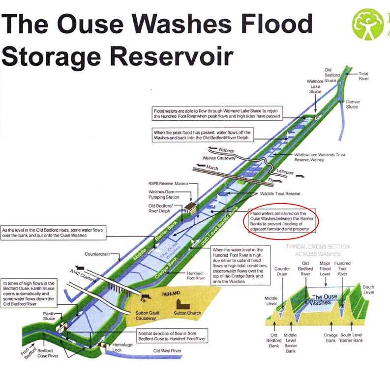
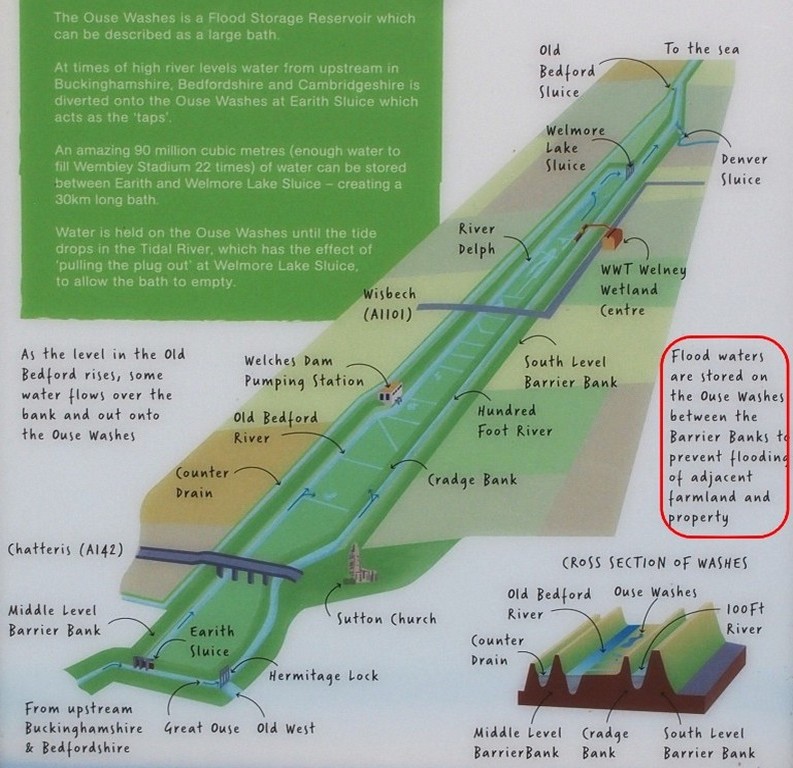 The EA's current Water Level Management Plan (WLMP) of 2002 describes the Washes status as a reservoir in para 3.2.6 stating that
the Act's regulations principally relate to the floodbanks which form the reservoir - MLBB and SLBB.
The EA's current Water Level Management Plan (WLMP) of 2002 describes the Washes status as a reservoir in para 3.2.6 stating that
the Act's regulations principally relate to the floodbanks which form the reservoir - MLBB and SLBB.It was therefore a surprise to many attending EA drop-in events in 2016 and 2017 about current major bank works (see below) to learn that the EA now say the sides of the washes are designated reservoir 'dams' and are no longer the two barrier banks, but the MLBB and the Cradge Bank (which incidentally was not part of Vermuyden's scheme, being built in the 1750s-1820s by when some incoming high tides could flow out into the Washes).
As 'dams' those banks are subject to different legislation to the SLBB which is no longer considered part of the reservoir and despite its huge importance is "just a river bank". The EA's design guide for flood storage was developed between Oct 2013 and May 2017. It classifies an area such as the Ouse Washes as an "offline reservoir" and needs the river to be separated from the storage area. (The river here being the Ouse in its guise as the New Bedford.) See EA's guide on the Gov.uk website at:
Reservoir banks have to be inspected twice-yearly by an engineer from a panel of experts, usually employees of consultancy or civil engineering companies (e.g. Mott MacDonald), in accordance with Section 10 of the 1975 act. Thus any recommendations for remedial action - "Matters in the Interests of Safety" (MIOS) to use the jargon - are known as 'Section 10 Works'.
The latest "Section 10 works" began in July 2017. (Cost £10m; design: Mott MacDonald; main contractor: Jackson; ground engineering and haulage: Mick George.) An odd thing is the work is on the MLBB - and the SLBB, which is not subject to section 10, but NOT the Cradge Bank which is.
Am I missing something?
Floodwater Storage adjacent to the Washes
Relief Channel
Part of the Great Ouse Flood Protection Scheme, this 11 mile (18km) long cut from Denver to Kings Lynn has a very important part to play in temporary floodwater storage.For details, please see section on: my Denver Sluice page.
Various ideas have been proposed and considered including the use of old quarry workings such as:
Block Fen, Mepal (west of Washes)
-- section awaiting content --see also New Bird & Wildlife Habitats (below) and Additional floodwater stoage areas on the History & Management page. (may not be posted yest)
Cross sections of Washes
The first two are from books in my personal library. The second is south of Welney, and I assume the first is too. Both have good points but neither is entirely accurate. Together, they provide a good guide to the relative position and levels of the rivers, banks and washes.The first is c1980. It is clear and informative. I don't know the data source but think the heights are probably "design" rather than actual. They are shown as "SLD" - South Level Datum - rather than AOD. (0mAOD = 100mSLD.) This is used in South and Middle Level areas, much of which are below sea level (ordnance datum), to avoid negative values (which are not always obvious - see note 1 below). There are quite a few gauge boards in or near the washes marked this way. It also shows widths which are useful but note the wash is a little wider elsewhere and only half that shown near Sutton.
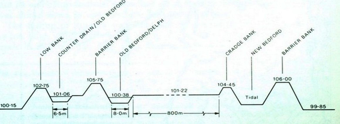
(source: The Changing Fenland," HC Darby, 1983, p210)
Next is 1997. It shows heights following major bank works 1992-94 bringing them back to (or near) design height after years of "settling" down. The horizontal dash line marks zero AOD.
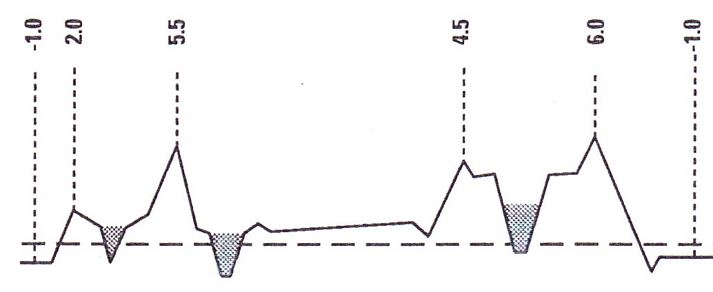
(source: EA OB LEAP, 1997)
The earlier plan correctly shows the "crests" (bank tops) are flat not pointed as in the later one. Since 1994 crests are at least 3m (10ft) wide providing a roadway for light vehicles used during inspections and maintenance.
Points to note on both, left to right (west to east)
- 1. The edge of the Middle Level. Land height varies but is nearly all below sea level. The negative value on the lower diagram is not very obvious.
- 2. The 'low bank' was the Middle Level Barrier Bank (MLBB) for a hundred years or so until the River Delph was cut (marked Old Bedford/Delph.) It now runs outside the Washes from WD to Salters Lode. Considerably lower in 1997 than earlier.
- 3. The Counterdrain/Old Bedford River. The 1980s drawing shows the bottom much higher than in the 1997 one. I believe the later one is correct but have no data to back that up.
- 4. The MLBB since the 1750s.
- 5. The Old Bedford/Delph River. In times of heavy upland flows water can flow over the eastern bank into the Washes. Level of bottom - as comment in 3 above
- 6. The washlands, popularly called the Ouse Washes, but originally (and to some still) known as the Hundred Foot Washes. Wrongly shown flat on the first, the later one correctly shows a gradient to the left (the west). (More on Washes in sections below)
- 7. The 'header' dyke ("Cradge Bank ditch") Not shown on the top diagram. During the summer this dyke is fed from the NBR and distributes water for irrigation.
- 8. The Cradge Bank. Was not part of Vermuyden's scheme. Added later (1800s?) to avoid high tides overflowing into the washes taking in silty saline water
- 9. The New Bedford or Hundred Foot River. Normal flows are within the "V"; very high tides can rise onto the flat banks each side shown on the lower plan; extreme high tides can "over-top" the Cradge Bank and flow onto the Washes so preventing the river flowing over the outer bank and inundating (potentially) thousands of acres of low fen lands in the South Level.
- 10. The South Level Barrier Bank.
- 11. Edge of the South Level which like the Middle Level, varies in height but is mostly below sea-level. again note in the lower plan a negative reading
The diagrams above are not wonderful, but nevertheless far superior to the dreadful one below found on the ousewashes.org.uk website. It was "created by Sheils Flynn for OWLP". If I were the OWLP I would demand my money back . It's horrible.
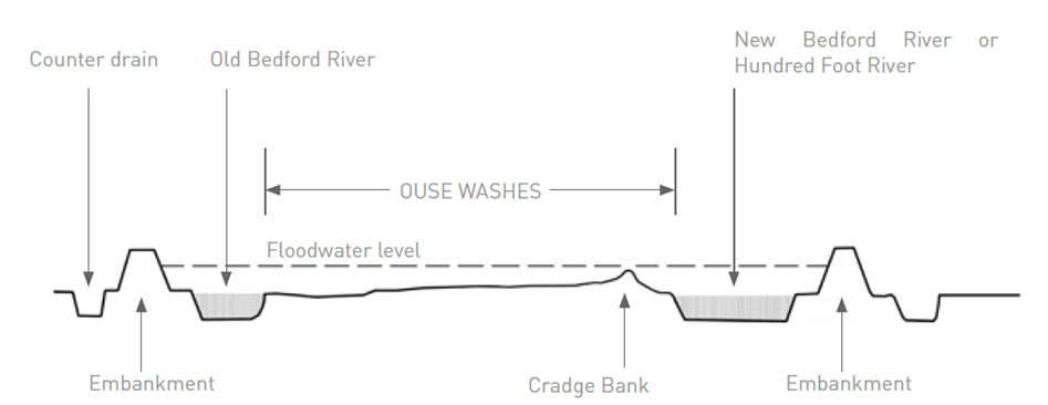 Counterdrain shown dry;
CD/OBR low bank omitted; 'embankments' not named; cradge ditch omitted; large dry drain on right doesn't exist; no level/height
values shown;
right edge of Washes shown in mid-air.
Counterdrain shown dry;
CD/OBR low bank omitted; 'embankments' not named; cradge ditch omitted; large dry drain on right doesn't exist; no level/height
values shown;
right edge of Washes shown in mid-air.OWLP was a 4-year £1m lottery-funded scheme with a full time manager with staff and large back up and this is the best they could do. Pathetic.
Beware flashy but misleading videos
In Feb 2013 some videos uploaded to YouTube by "GreenVenturesTV" used incredible imagery to try to demonstrate the workings of the Washes. Technically brilliant in some ways but which may be misleading in some respects such as the still frames shown here.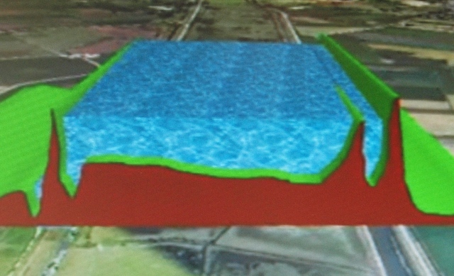
Image on right from the video shows the fall across the washes sloping down to the right, i.e. eastwards, and the western river, the Counterdrain/Old Bedford, lower than the Old Bedford/Delph next to it.
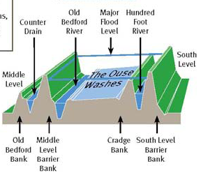
The diagram on left from an EA brochure (EA OB LEAP, 1997) shows the generally accepted "norm" with the washes draining to the left i.e. westwards, into the Old Bedford/ Delph River.
The western river, the Counterdrain/Old Bedford, is shown here higher than the old Bedford/Delph, as it is on both diagrams in the previous section of this page.
Graham Redman from Sutton e-mailed 23/02/13 to comment on my original statement that the video image showed the slope incorrectly:
"I do have to wonder what the LIDAR data source is. Is there any chance the profile from the video is actually correct and demonstrates why there are problems getting water off? I presume env agency data from their report comes from ground level surveys"Well maybe Graham has a point; there are a few washes which remain wet (eg one just south of Sutton Gault) but the general lay of the land (90%?) is to the west, draining into the Delph. The system wouldn't work otherwise. Explanations should show the norm not the exception.
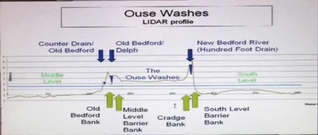 What cannot surely be defended is the image on the left from
the video, showing grossly inaccurate levels of the NBR and its banks; and wrongly marking the Middle
Level Barrier Bank.
 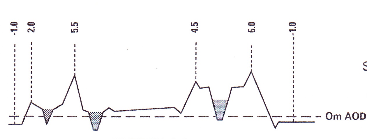 This diagram correctly shows the outer (barrier) bank of the Old Bedford/ Delph is higher than
the inner (cradge) bank of the New Bedford/100 Foot,
This diagram correctly shows the outer (barrier) bank of the Old Bedford/ Delph is higher than
the inner (cradge) bank of the New Bedford/100 Foot,Washlands
The only notable features in the washes (as opposed to around them) are the earthworks near Earith called the Bulwarks; the embankments and viaducts of the railway line; the road viaduct and a small group of houses at Mepal; the road causeways at Earith, Sutton and Welney; some cattle pens dotted around; and the WWT observatory north of Welney.Also, throughout, a surprising number of trees.
When in flood, the waters in the washes flow downstream from south-west to north-east. But there is an extra dimension - the wash lands are generally higher on the east, so when not in flood, the field drains take waters north-westwards across the washes towards the Old Bedford/Delph (OB/D) river. The gradient is natural, and gentle, a fall of 12 to 18 inches (0.3 to 0.45M). This sideways flow has to be controlled and not allowed to simply drain into the OB/D because the internal ditches need to be kept filled during summer as explained elsewhere.
The cross-section diagram in the section above is north of Welches Dam (WD) about halfway between the railway and the A1101, with levels expressed in metres "AOD" - above ordnance datum, i.e. above "sea level".
For an explanation of the river names see above.
Sluices, locks, dams and weirs
It is often difficult to understand the early operation of water control structures when reading past accounts due to terminology. Sasse and sluice seem to be used by different writers to describe the same feature, neither indicating (to me) whether navigation was possible. When navigation is mentioned, it is unclear whether that was only when water levels each side were virtually the same enabling a gate to be lifted or a single set of mitre (vee) gates or doors to be opened, or whether the structure was a true lock with 2 sets of gates allowing passage at any time regardless of differences in levels.The dates show when structures were erected or dams formed at a location, but should not be taken to be the date when the current type of control was introduced. Use the links in the left column to visit pages with gretater detail and photos.
The water controls listed below are all owned by the EA except Salters Lode and Horseway Locks which are owned by the MLC; and the Mepal Lock which is in land owned by the RSPB and the drainage area of the Hundred Foot Wash IDB
Old Bedford Sluice is operated for navigation purposes only by the MLC lock-keeper at Salters Lode on behalf of the EA, otherwise operated by the EA staff at Denver.
| sluice/lock name & keeper's tel | location, rivers & OS grid ref |
built, rebuilt |
openings, gates2 | current dimensions1 and sluice operation |
||||||
| cillAOD | width | length | depth | hd/rm | head | |||||
| Hermitage Lock | Earith GOR to OWR TL 394 746 |
1651 1826 1968 |
? V-V V-V |
0.0 | 4.0m 13'1" 12'6" |
30.5m 100ft 90ft |
1.5m 5ft |
2.75m |
3.4m 11ft |
|
| Earith Sluice |
Earith GOR to OBR TL 388 747 |
1651 1824 1954 |
9 ? 7 ? 3 R |
0.62m |
6.71m |
automatic when Bedford Ouse reaches set
levels (drawmarks) 3.77 summer (Apr-Oct)7 3.17 winter (Nov-Mar)8 |
||||
| Black Sluice10 | 0.8m N of Earith. Cranbrook Drain to OB/DR TL 3971 7595 |
P | 0.60m | Manual. | ||||||
| Mepal lock | NBR to OBR | c1810 | V-V | n/k | 10'8" | 123ft | n/k | n/a | ||
| Forty Foot Lock3 | Welches Dam 40-ft to OBR TL 469 858 |
1651 1991 |
V-V V-V | -0.9m |
3.7m 12'2" 11ft | 47ft | not known | not known | ||
| Horseway Lock4 | 40ft MLC to 40ft EA | >18484 1985 |
V-V V-V |
min 12ft 11ft | min 50ft 60ft | min 4ft n/known | n/a | |||
| Welney Sluice (Welney Gate)9 |
Welney OBR TL 5295 9384 | 1973 | G | -0.6m | 4.3m 14'1" | n/a | not known | not known | ||
| Well Creek weir | Salters Lode OBR to WC TF 5855 0145 |
1.65m | automatic 3m wide flood spillway into MLC area if OB sluice can't be opened | |||||||
| Welmore Lake Sluice (John Martin Sluice) |
Welmore Lake DR to NBR TL 572 987 |
1825 1933 1999 |
4 V 2 G-V 3 G-V |
-1.4m | 7.3m | Lift Gates set daily by visiting Denver staff. Vees open by gravity when NBR level permits |
||||
| Old Bedford Sluice
(Lock) | Salters Lode OBR to GOR TF 5860 0152 | 1630 1652? 1828 1991 |
? ? V-V G-V |
-0.53m | 4.3m 14'1" | short | not known | not known | ||
| Salter's Lode Lock 01366 3823405 |
Salters Lode WC to GOR TF 5860 0162 | 1630 1652? 1828 2008 |
? ? V-V G-V | 3.8m 12'6" 12'6" |
24.4m 80ft 62ft | not known | 2.4m | |||
| Denver Lock6 |
Denver Ely Ouse to Tidal River TF 588 010 | 1730 1834 1924 1984 | V-V V-V ? G-G | -0.58m | 5.4m 17'8" |
29.5m 96'9" |
2.04m 6'8" | not known | ||
| Denver Sluice
6 "Little eyes" |
Denver Ely Ouse to Tidal River TF 588 010 | 1651 1730 1834 1924 1987 |
? ? 3 V-V 3 G-V 3 G-V | -2.7m | 1x5.0m 2x5.4m | see my Denver Sluice page, operating rules | ||||
| Denver Sluice6 "Big Eye" |
Denver Ely Ouse to Tidal River TF 588 010 | 1923 19?? |
G-G G | -3.5m | 10.7m 35ft |
approx 15.5m 50ft | not known | not known | ||
| Main source: EA OW WLMPs, 1996, 1998, 2002. | |
| 1 | Lock dimensiions in italics from Jim Shead's canals website; others from EA WLMP & GOR map; Andrew Hunter Blair: River Great Ouse and tributaries |
| 2 | G = "Guillotine" vertical lift gate; V = "Vee" mitred gates/doors; R= Radial gate; F=Flap gate; P=Penstock; D=Dam boards. Two letters indicate a set of gates/doors, 1st is upstream, 2nd downstream; Digits indicate number of sluice openings. |
| 3 | Disused and blocked off. The EA renamed it Welches Dam Lock |
| 4 | Disused but appears generally sound. ML Act 1848 authorised/required MLDC to build a pen sluice to keep water from Old Bedford out of the ML,subject to navigation rights. |
| 5 | Or 01366 382 292 |
| 6 | Denver Sluice has a navigation lock; three non-nav sluice gates known as "little eyes"; and an old very large once-navigable gate known as the Big Eye which is redundant and sealed-off. Denver is not part of the Ouse Washes, although is does have a considerable effect, and is also the operations centre for the Ouse Washes control structures |
| 7 | WLMP 2002 referred to OW Flood Control Strategy (FCS) recomendation toincrease summer drawmark to 3.81 to limit summer flooding of the Washes |
| 8 | The Great Ouse Tidal River Strategy (GOTRS) in 2009 recommended raising winter drawmark to 3.77 which would mean less water stored so quicker draining, and increase flow on NBR to help manage siltation. |
| 9 | Normally raised allowing navigation but closes without warning when Welches Dam PS is about to operate, both events automatically triggered when river level at WD reaches a pre-determined figure. |
| 10 | filled-in during bank-raising works c2020 |
Pumping Stations
| From south to north | discharge from/to1 | OS grid ref (all TL) |
built, power | output2 m3/s |
owner |
| Over | SL to BO | 3918 7455 | 1941 D 1971 E |
- 1.02 |
Over & Willingham IDB |
| Sutton Gault | SL to NBR | 425 789 | n/k D 1971 E | - 1.32 | Haddenham Level DC |
| Fortrey's Hall | ML to CD | 441 822 | 1749 W 1840 S 1926-8 D 1990 E | - - 2.55 + 3.00 | Sutton & Mepal IDB |
| Middle Level Transfer Welches Dam | OBR to ML | 4704 8581 |
EA (MLC?). Demolished 2015-16 (?) | ||
| Welches Dam | OBR to DR | 4712 8592 |
1948 D 2011 E |
12.63 10.05 | Environment Agency |
| Old Mill Drove | ML to CD/OBR | 4721 8619 | 1920s? D? | Manea & Welney DDC? | |
| Oxlode | SL to NBR | 482 858 | 2.29 | Littleport & Downham IDB | |
| Purls Bridge | ML to CD/OBR | 4845 8790 | 1970s? | 1.13 | Manea & Welney DDC |
| Westmoor Mills Hundred Foot | SL to NBR | 508 892 |
1756 W 1830 S 1926 D & S 1951 D & D 1985 E |
- - - 3.38 + 5.10 | Littleport & Downham IDB |
| Glenhouse (Colony) | ML to CD/OBR | 5115 9148 |
1760 W 1842 S 1928 D 1948 D 1998 D |
- - - 5.08 5.83 | Manea & Welney DDC |
| Cock Fen | ML to CD/OBR | 5438 9587 | 1975 D | 2.04 | Upwell IDB |
| Upwell Fen | ML to CD/OBR | 5649 9870 | ? E | 0.51 | Upwell IDB |
| Welmore Lake | Delph to NBR | 2010 E | Environment Agency | ||
| Lake Farm | Washes to CD/OBR | 5742 9984 |
?? D ?? E |
0.285 | private |
| 1 | SL=South Level; ML=Middle Level; OBR=Old Bedford River; NBR=New Bedford River (!00 Ft River); DR= Delph River; CD=Counterdrain; WC=Well Creek; BO=Bedford Ouse; RGO=River Great Ouse |
| 2 | Figures as shown in OW WLMP 2002; see individual PS pages for output of previous engines/pumps |
| 3 | |
| 4 | OW WLMP 2002 |
| 5 | Note reduction in output on conversion to electric. I understand this was due to maximum overhead supply being limited to 1000kva. It was considered un-economic to upgrade supply to provide sufficient power for more or larger pumps. |
Slackers and irrigation inlets
Counterdrain/Old Bedford
There are 3 slackers for irrigation, 1 to feed an amenity, and 1 pumped irrigation point| Name, south to north | OS grid ref all TL |
owner (IDB) | cill OD | built | |
| Argents farm | 434 810 | Sutton & Mepal IDB | 0.75 | ||
| Fortrey's Hall | 441 822 | Sutton & Mepal IDB | 0.75 | ||
| MLC transfer station, Welches Dam | EA | ||||
| Glenhouse2 | 511 915 | Manea & Welney DDC | none | ||
| Old Croft3 | 528 936 | Upwell IDB | 0.91 |
| Main source: EA OW WLMPs, 1996, 1998, 2002. | |
| 1 | |
| 2 | due to be replaced (Done 1999?) |
| 3 | The IDB says the Old Croft is not used for irrigation or drainage (amenity to maintain.old river) |
| 4 |
New Bedford/Hundred Foot River
There are 17 slackers allowing water onto the Washes, and 5 into the South Level| Name,
from south to north |
OS grid all TL |
pipe diam/type |
gate operation, material, type |
cill OD | owner (IDB/DC) | IDB ref | built |
| Earith Hundred Ft | 397 752 | Haddenham Level | |||||
| Black Sluice1 | 398 754 | 1.30m brick tunnel | screw timber penstock | Hundred Foot | 34 | ||
| Youngs Holt | 409 768 | 0.225m glazed clay | handlift wood penstock | Hundred Foot | 32 | ||
| Sutton Drove | 423 788 | 0.3m concrete | handlift steel penstock | Hundred Foot | 31 | ||
| Sutton Gault | 425 789 | Haddenham Level | |||||
| Reads (near pits) | 433 804 | 0.3m concrete | screw steel penstock | Hundred Foot | 30 | c1798 | |
| Witcham Gravel | 455 825 | 1.30m brick tunnel | screw steel penstock | Hundred Foot | 28 | ||
| Jerusalem Drove | 459 828 | Littleport & D'ham | |||||
| Pontoon wash | 465 836 | screw steel penstock | Hundred Foot | 27 | |||
| Common Wash | 467 840 | screw steel penstock | Hundred Foot | 26 | |||
| Ely Singers | 475 851 | 0.40m glazed clay | screw steel penstock | Hundred Foot | 25 | ||
| Oxlode | 486 864 | screw steel penstock | Hundred Foot | 22 | |||
| Oxlode irrigation | 472 858 | Littleport & D'ham | |||||
| Cambient | 498 880 | 0.40m c/g steel | screw steel penstock | Hundred Foot | 18 | ||
| Dimmocks | 5015 8846 | 0.15m steel | screw steel penstock | Hundred Foot | 17 | ||
| Hundred Foot | 510 894 | Littleport & D'ham | |||||
| Hartleys | 512 898 | 0.40m c/g steel | screw steel penstock | Hundred Foot | 13 | ||
| Kents | 517 904 | 0.3m polypropylene | screw steel penstock | Hundred Foot | 11 | ||
| Motts | 528 921 | 0.45m concrete | screw steel penstock | Hundred Foot | 7 | ||
| Deptfords | 539 936 | 0.45m concrete | screw guillotine | 1.60m | Hundred Foot | 4 | |
| Charity | 552 954 | 0.45m concrete | screw guillotine | 1.65m | Hundred Foot | 2a | |
| Hagen Smart | 562 969 | 0.45m concrete | screw guillotine | 1.60m | Hundred Foot | 2 |
| Source: NRA OW WLMP, March 1996; EA OW WLMP, 2002, Fig 6 for HFW IDB refs. |
More information and photos are on my
Warehouses
In 1830 Wells records that the BLC had four store-houses or warehouses where tools and materials were kept for immediate use in times of flood. Those in the area of the Ouse washes were at:
- old bank between Welche's Dam and Welney
- Denver Sluice
- Oxlode
Causeways and bridges - past and present
| Location, sth-nth, grid ref | name &/or type | across1 | construction | built rebuilt |
demol ished |
access |
| Earith sluice | road bridge | OBR | ||||
| Earith | causeway | Washes | ||||
| Earith | road bridge | NBR | cast-iron | 1826 | ||
| Sutton Fen | road bridge | CD | private | |||
| Sutton Fen | road bridge | OBR | private | |||
| Sutton Chain | ferry | washes | ||||
| Sutton Gault | road bridge | CD | ||||
| Sutton Gault | road bridge | OBR | concrete | |||
| Sutton Gault | causeway | washes | tarmac | |||
| Sutton Gault | footbridge | washes | timber | 1938 | ||
| Sutton Gault | road bridge | NBR | concrete | |||
| Mepal bypass | road bridge | CD | 1985 | |||
| Mepal bypass | road viaduct | OBR, Washes, NBR | concrete | 1985 | ||
| Engine Bank | (old) road bridge | CD | ||||
| Mepal | road bridge | OBR | concrete | 1930 | 1985 | |
| Mepal | road viaduct | washes | concrete | 1930 | 1985 | |
| Mepal | road bridge | NBR | concrete | 1985 | ||
| Mepal | road bridge | NBR | concrete | 1930 | ||
| Mepal | road bridge | NBR | timber | pre 18924 | 1930 | |
| Mepal | ferry | |||||
| Fortrey's hall | drain | brick arch | ||||
| Engine Bank | footbridge | CD | ||||
| Welches Dam | bidge on lock | 40 ft | 17 ton limit | |||
| Welches Dam TL 4707 8580 | DR | steel Bailey5 | ||||
| Welches Dam TL 4707 8592 | CD/OBR | |||||
| Welches Dam TL 4714 8595 | outlet | steel Bailey5 | ||||
| Oxlode | NBR | yes | to PurlsBr | |||
| Washes | road causeway | washes | ||||
| Purls Bridge | CD/OBR | yes | to Oxlode | |||
| Purls Bridge | DR | yes | to oxlode | |||
| Pymoor | rail over road | road | ||||
| Pymoor | rail over river | NBR | steel through truss | |||
| Washes | rail viaduct | washes | ||||
| Washes | rail embankment | washes | ||||
| Washes | rail viaduct | washes | ||||
| Manea | rail bridge | DR | ||||
| Manea | rail bridge | CD/OBR | steel through truss | |||
| Welney | ferry | washes | ||||
| Welney |
Old Bedford Br road bridge | OBR | cast iron | pre 18502 | yes | |
| Welney | Old Bedford Br road bridge |
OBR | concrete | n/k, 1994 |
||
| Welney | Delph Br road bridge | DR | timber | pre 18502 | yes | |
| Welney | Delph Br road bridge | DR | concrete |
n/k, 1994 | ||
| Welney | Wash Road road causeway | washes | tarmac | |||
| Suspension Br | The Br of
Suspension road bridge | NBR | wrought iron chain suspension | 18243 | 1926 | |
| Suspension Br | Suspension
Br road bridge | NBR | concrete bow string arch | 1926 | 1996 | |
| Suspension Br | Suspension Br road bridge | NBR | steel reinforced concrete | 1996 | ||
| WWT reserve | footbridge | NBR | restricted | |||
| Welmore Lake | road bridge over sluice | DR | public by foot | |||
| Denver Sluice | road bridge over sluice | RGO | ||||
| Salter's Lode TF 5849 0147 | road bridge | WC | 1999? | to fm & WL | ||
| Salters Lode TF 5854 0142 | road bridge | OBR | 1999? | to fm & WL | ||
| Salter's Lode TF 5860 0159 | road bridge at sluice | WC | brick arch | 1828? | ||
| Salter's Lode | OBR |
| 1 | OBR=Old Bedford River; NBR=New Bedford River (!00 Ft River); DR= Delph River; CD=Counterdrain; WC=Well Creek; RGO=River Great Ouse |
| 2 | Gardner's 1851 History of Cambridgeshire & Isle of Ely, pages 565-6. |
| 3 | Other sources say Susp Br built 1826 |
| 4 | from photo in Mepal Community archives |
| 5 | a pin-connected truss bridge similar to a UK military bridge. Further details and photos old & new go to the Bridges and causeways page |
Ferries
| at, or between | and | ferry house | operational | operators |
| Sutton Chain | Sutton Fen (Jolly Bankers) |
|||
| Mepal |
over the washes | W of NBR | until 1930 when 1st viaduct built | John Waters was the last, buried at Mepal |
| Welney | Suspension Bridge | E of OBR | James family | |
| Suspension br | over the NBR only | until 1825 when bridge built over the NBR | ||
Where there was a ferry service, there was nearly always a pub on both sides where passengers could shelter whilst waiting or warm up on arrival. See next section.
back to contents
Pubs and inns
What have pubs to do with the history and operation of the washes? Quite a lot; where else could all those engaged in digging the cuts and building the sluices live, or spend their wages and enjoy some leisure? And who better to provide them than the land owner and employer.Samuel Wells, in his 1830 work, vol 1, pps 631-632, lists 20 pubs owned by the Bedford Level Corporation ("BLC") which he says were used to
"house travellers and labourers employed in the vicinity; the latter particularly in times of flood, are there supplied with food and shelter, during their daily and nightly exertions in the protection of property."The pubs were leased every six years, by auction. The BLC accounts for 1830 shows the annual rents for the 20 totalled £696 (p635), and expenditure to "build and repair" of £277-8s-8d (p643). Four of these were some distance from the banks of the Washes, and excluded from the list below.
Other bank-side pubs that were either built after 1830 (co-incidentally the year the Government introduced the Beer Act) or were not BLC ones, are included.
| Name | Location | OS grid ref | built | 1830 | brewery/owners | |
| Fish | Sutton Chain | BLC 1 | ||||
| Jolly Bankers | Sutton Fen | |||||
| (Chain) | Sutton Gault | Harlock 1822 | ||||
| Fish | Sutton Gault | BLC 9 | closed 1963 | |||
| Anchor | Sutton Gault | NBR | 1650 | BLC 2 | ||
| Three Pickerels 1 | Mepal bridge | NBR | BLC 3 | |||
| Three Horseshoes | Oxlode | NBR | BLC 4 | |||
| Crown | Oxlode | NBR | BLC 5 | |||
| Victoria | Welches Dam | OBR | Kellys, 1891, 1916 | |||
| Three Fishes | Welches Dam or Purls Bridge? | OBR | BLC 10, & 11 | Wells lists this twice, both at Welches Dam | ||
| Ship Inn | Purls Bridge | OBR | BLC 15 | |||
| Chequer | Purls Bridge | OBR | BLC 14 | |||
| Three Tuns | Bedford Bank East, Welney | OBR | BLC 12 | |||
| Crown | Suspension. Br | NBR | BLC 6 | |||
| Welney Hotel | Bedford Bank West, Welney | OBR | 1844 | no | ||
| Dog and Duck | 100 ft Bank, Hilgay | NBR | BLC 7 | |||
| Bridge | Earith | |||||
| Hardwicke Arms | Hermitage | BLC 8 | ||||
| Green Man | Bedford Bank West, Welney | OBR | BLC 13 | |||
| Ship | Denver Sluice | BLC 18 | Norfolk Pubs says this is also Jenyns Arms | |||
| Jenyns Arms | Denver Sluice | free house | ||||
| Crown | Denver Sl;uice | demolished 1950s | ||||
| Eagle Tavern | Bedford Bank West, Welney | OBR | ||||
| Carpenters Arms | Suspension Br | NBR | ||||
| Cock | Suspension Br | NBR | ||||
| Jolly Waterman | Salters Lode | WC | later moved to lock-keepers hse ? | |||
| 1 | named "Toad Hall" in the late 1980s |
Further details and photos old & new go to the Pubs and Inns page
back to contents
Houses
Recording the houses along the river banks of the Ouse Washes is going to be a long job, and I will not be tackling it seriously until the main project is finished. However for various reasons I have recorded a few of the more interesting ones and these are listed below.Counter Drain/ Old Bedford River
| Name | Location | OS grid ref | built | owners |
| Fortreys Hall | Engine Bank, Mepal | |||
| Lock Keepers cottage | Welches Dam | |||
| anon | Welches Dam | |||
| Princess Victoria | Welches Dam | |||
|
Colony House | Bedford Bank West, Welney | |||
| Bridge House | Bedford Bank West, Welney | |||
| (Old) Welney Hotel | Bedford Bank West, Welney | |||
| Norway House | Bedford Bank East, Welney | |||
| derelict house | Bedford Bank East, Welney | |||
back to contents
Wartime defence instalations
| Item | Location | OS grid ref | built |
| Earthworks | The Bulwark Earith Washes | Civil War | |
| Spigot Mortar emplacement (only the base remains) | nr Teal
Cottage Suspension Bridge |
TL 536 928 TL 535 9281 | WW2 |
|
Spigot Mortar emplacement (only the base remains) | east side of CD/OBR sth of bridge at Welney |
TL 527 935 TL 528 9361 | WW2 |
| Spigot Mortar emplacement (only the base remains) | The Bulwark Earith Washes | TL 3925 7491 | WW2 |
|
Spigot Mortar emplacement (only the base remains) | Sutton Gault grass verge nr pub |
TL 4291 7963 | WW2 |
| Metal domed M/gun emplacement | The Bulwark Earith Washes | TL 3930 7500 | WW2 |
| Pillbox | White Hall Farm at Salters Lode | TF 5859005 | WW2 |
| Pillbox type FW3/24 | TL 448864 | WW2 | |
| Pillbox | TL 457862 | WW2 | |
| Pillbox | TL 479852 | WW2 |
| 1 | the second grid ref is that shown on the defence of Britain database |
For more details and photos of the particular site click links above or go to the Wartime Installations page
back to contents
Cattle Pens
| Name | Location | OS grid ref | built | owners |
| nth-west of Susp Br, nth side of A1101 | TL 5348 9287 | RSPB | ||
| Cradge Bank | west of Susp Br sth side of A1101 | TL 5342 9285 | RSPB | |
| washes, west of NBR nth of Kents slacker | TL 518 909 | RSPB | ||
| east of Delph Br nth side of A1101 | TL 5305 9361 | RSPB | ||
there are others to be added to this list
Further details and photos go to the Cattle Pens page
back to contents
Boating
Nature & Wildlife reserves
In 1964 the RSPB made their first acquisition in The Ouse Washes, buying some land south of Welney, and in 1965 more land was bought by what became the Cambridgeshire Wildlife Trust. Also in 1965 the Wildfowl & Wetlands Trust (WWT) bought some land north of Welney.Acquisitions by all three continued over the next 35 years, and by 2000 they owned between them about 75% of The Washes as detailed on the introduction page ownership section.
Their conservation and wildlife activities are described on their own sites; here I will simply be recording the buildings they have erected - their visitor centres, bridges, hides, stock buildings and workshops.
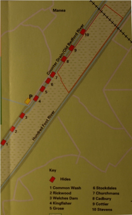 On the left is the layout of part of the RSPB reserve showing the 10
hides.
P marks the car park next to the Visitor Centre - a very simple
shed - the emphasis here is on seeing the birds and other wildlife.
There are no charges for use of the centre, car park or hides, and nowhere to spend any money. Bring your own food & drink, there is a free picnic area.
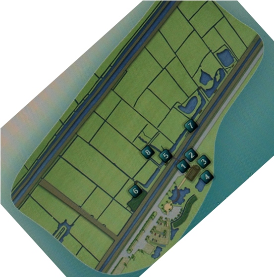 On the right is the plan of the WWT reserve.
There, parking and entry to the Visitor Centre is free, but there is a charge for entry to the observatory and reserve, and the shop & restaurant are also happy to take your money. Nos 1-2 are the visitor centre and Widgeon restaurant.
see also New Habitats (below) and Conservation on my History & Management page.
New Areas for Bird & Wildlife Habitat adjacent to Washes
In recent years more frequent flooding of the Ouse Washes in spring and early summer and longer and deeper flooding in winter has resulted in a deterioration in the habitat suitable for certain wildfowl and a subsequent decline in their numbers.
The Environment Agency (EA) concluded that it would be too expensive to improve the Washes and a better option would be to create new wetland areas nearby.
WWT, Lady Fen, Hundred Foot Bank, Welney
In 2006 the EA bought 38 hectares (94 acres) of farmland alongside the WWT's visitor centre on the Hundred Foot Bank, on the east of the Washes.
The EA said it was to compensate for flood defence work carried out on the Middle Level (ML) Barrier Bank. Apart from the fact that the ML barrier bank is on the western side of the washes, I don't understand how raising & /or strengthening river banks affects wildfowl.
Anyhow, work began on site in 2008 by digging ditches, channels and scrapes, laying a waterproof liner, seeding with native grasses and providing controls for water depth. The new wetland now provides ideal winter accomodation specifcally for wigeon (500 in the first year), but it has also attracted other species and may also help black-tailed godwits which have suffered badly from summer floods washing away their eggs and chicks.
The surrounding grassland provides summer grazing for cattle and sheep, and the site is managed for the EA by the WWT
RSPB, Welches Dam, Manea
-- section awaiting content --EA, Habitat Creation Programme, Coveney and Sutton
An undated but apparently very recent EA publication said:"The objective of the project is to create at least 500 hectares (1,200 acres) of new wet grassland habitat to restore the populations of black-tailed godwit, snipe and ruff during the breeding season as well as wintering wigeon.See local MP's concerns regarding this plan.
The new habitat has to be close to the existing Ouse Washes with suitable soils and sufficient supply of water to create the optimum conditions for nesting and feeding birds. We have identified two sites close to the villages of Coveney and Sutton, Cambridgeshire, that meet the habitat requirements. Over the last few years we have been working with local landowners to agree land for the project.
The map (below) shows the location of the two sites and the approximate extent of the area we hope to create as new habitat.
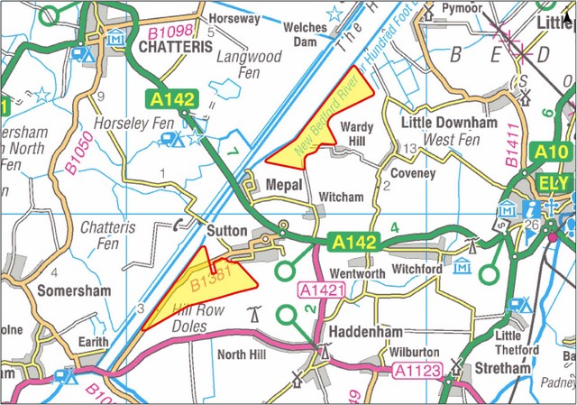
Government has asked us to deliver the project on its behalf and is providing funding through an annual allocation to progress this work."
Block Fen, Mepal (west of Washes)
-- section awaiting content --see also New areas for floodwater storage (below)
see also Nature Reserves (above) and Conservation on my History & Management page.


Page created May 2011, last edited: 30/11/25, 09:11