The
|
|
Mepal lock and canal - "the Great Dyke and sluice"
back to top of page and contents
- Contents of this page
- related pages on this site
- related pages on other sites
- Home page and full site index
- Recommended OS Maps
- Site designed and written by
Peter Cox 
Site designed before Tablets and Smartphones whose screen sizes and operating systems limit display and features. I've made some adjustments for those devices but viewing will not be as easy or clear as on PC/LT. - page created: 01 Feb 2013
- last updated: 29 Oct 2025
- Please "refresh"/"reload" page
Your computer stores images of webpages you visit in a "cache". When you re-visit, the stored page may be displayed. To see if it has changed, click the "refresh" or "reload" icon at top of screen. Designs/colours vary, examples:


- Copywright, acknowledgements
- Can you correct/add anything?
| VIEWING ON SMARTPHONE ? Go to phone page |
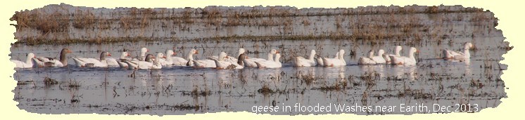
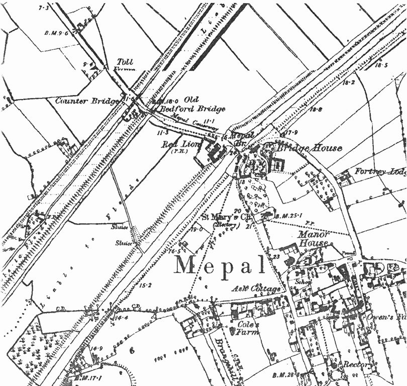
 A hundred yards or so west of the Mepal by-pass viaduct carrying the A142 main road over the Washes and visible from it, is a
bush-and-tree-lined feature running right across the Washes parallel to the viaduct.
A hundred yards or so west of the Mepal by-pass viaduct carrying the A142 main road over the Washes and visible from it, is a
bush-and-tree-lined feature running right across the Washes parallel to the viaduct.
It is the line of the "Great Dyke".
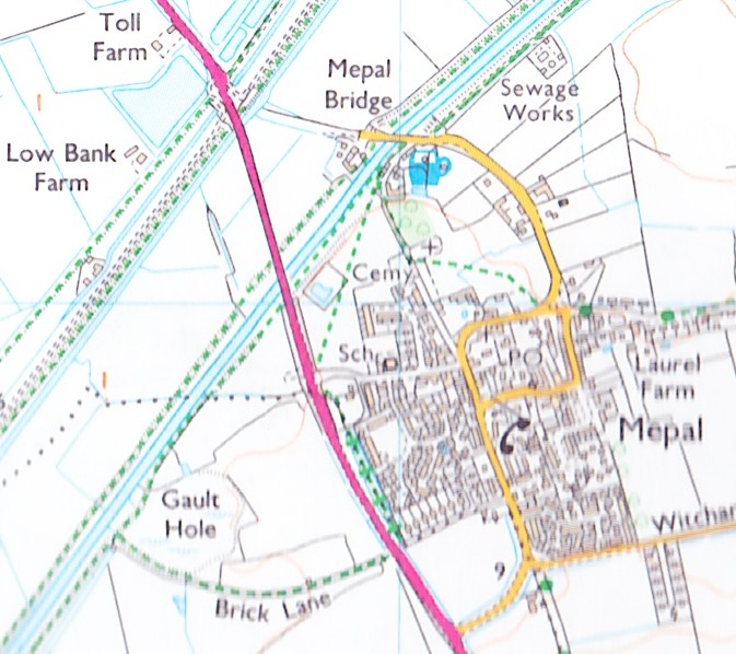
On this OS map the A142 is red; the Dyke is to the left of the road shown by a thin blue line partially surrounded by a black one.
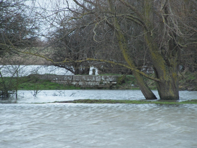
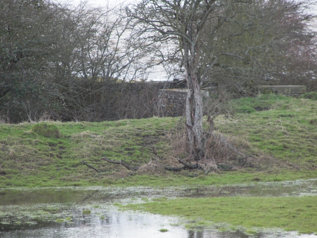 Near the south end of the Dyke, on what appears to be a small island, are the remains of an old lock, seen here from the viaduct in Jan 2013 when
the Washes were partially flooded. (photo: EE)
Near the south end of the Dyke, on what appears to be a small island, are the remains of an old lock, seen here from the viaduct in Jan 2013 when
the Washes were partially flooded. (photo: EE)
My attention was first drawn to this in Jan 2013 by David Stimson, the district officer of the Sutton & Mepal IDB, although a couple of years before I had seen a photo of the lock on the Mepal Community Archives website but hadn't realised its location, or significence.
 The photo was dated 1982. Note the stone structure near the top right. It enclosed a pair of sluice "V" gates, the northern end of the lock. Remains
of the wooden gates, or doors, can be seen; the corner stone of the other gate enclosure at bottom left; and the unusual width and length
of the unlined lock.
The photo was dated 1982. Note the stone structure near the top right. It enclosed a pair of sluice "V" gates, the northern end of the lock. Remains
of the wooden gates, or doors, can be seen; the corner stone of the other gate enclosure at bottom left; and the unusual width and length
of the unlined lock.The waterway is referred to in old records variously as a dyke, dike, ditch or drain and now as a canal, all of which I'm happy with, but I cannot understand why it's called "Great" when by comparison with the two rivers it joins it is just a tiddler. Irony, perhaps?
Use
To enable gault clay from pits on the south-east side of the 100 Foot river to be transported by boat directly to the north-west side of the Old Bedford River for repair to the Middle Level Barrier Bank that protected the low fens to the west, avoiding the long journey via Salters Lode.
The BLC archives record that in 1815 a barge owned by Thomas Gilbert, a gaulter working for the Board, sank under Mepal Bridge.
I wonder if his barges would have used the Great Dyke? (S/B/SP/1045 1815)
I wonder if his barges would have used the Great Dyke? (S/B/SP/1045 1815)
Later he refers to "Owen's Sluice and Drain, across the Wash near Mepal, erected for boating silt and high-land eath from Branghill Pits, near Sutton, for the repair of the banks on the opposite side of the Wash." (John Owen was a BLC Superintendent responsible for the area - see next section).
History
I haven't found evidence of when the dyke was dug but it was certainly prior to 1786 because in that year it needed scouring out according to a document in the BLC archives (see chronology and notes in next section).Now comes a mystery. Other documents suggest that there was no sluice until much later. For instance, a petition dated 1805 calling for one. So how could a dyke linking rivers of different, and differing, levels (one tidal, the other not) enable navigation without a sluice? Further north-east at Welmore Lake from 1756 to 1825 floodwater flow from the River Delph into the 100ft River was via an earth dam that had to be cut through then re-made but that surely could not have been the case here. I have only read summaries of documents about the dyke in the BLC archives, not the actual documents, and it could be that research by others will provide an explanation.
The 1805 petition was successful, a sluice being erected, possibly in 1810, but certainly before 1813 because by then it required "attention".
Now comes a second mystery. One researcher has suggested that the c1810 work was for a single sluice gate, with a second installed later, date yet undetermined. I and others consider a single gate would have been as impractical as none at all, and that only a 'pen-sluice' (i.e. an enclosed lock with gates each end) would enable passage for boats.
In 1816, John Owen was elected Superintendant for the South Division of the BLC's Middle Level, and that same year we learn the great Sluice was to be repaired.
Chronology below suggests c1838-c1842.
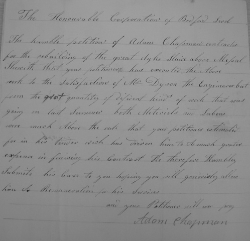 One early piece of help I received was from Australia. Gillian Kendrigan sent me a copy
of a petition she came across while visiting England researching family history.
One early piece of help I received was from Australia. Gillian Kendrigan sent me a copy
of a petition she came across while visiting England researching family history. It concerned work on the lock by Adam Chapman, a contractor from Nordelph, who "rebuilt the great dyke Sluice above Mepal" to the satisfaction of Mr Dyson the BLC Engineer (or Superintendent-General) but had to pay more for materials and labour than he allowed for in his tender due to the large number of other works (unspecified) going on at the time of his work, and he had to petition for his extra expenses.
Unfortunately the petition is undated, simply being endorsed "received 12 o'clock Wednesday morning". In the Cambridgeshire Libraries on-line catalogue of BLC archives, the year date of the bundle containing the document is shown (now) as "nd[1842?]". As pointed out by Dr N.James, that is just a guess, and at the time of this July 2016 update cannot be substantiated.
 When I started this page in late Jan 2013 the Washes had been flooded almost
continuously for several months.
This is a view of the stone work of the southern end of the lock taken from the South
Level Barrier Bank, i.e. the far side of the 100 Foot river. (photo: EE)
When I started this page in late Jan 2013 the Washes had been flooded almost
continuously for several months.
This is a view of the stone work of the southern end of the lock taken from the South
Level Barrier Bank, i.e. the far side of the 100 Foot river. (photo: EE)It was the end of February 2013 before the floods had abated sufficiently to allow access to take measurements and draw some simple sketchs (below) .
Chronology
| year | item/detail | source / CALM |
| 1771 | Gault pits at Sutton Brangehill. Quantity dug to be measured & valued and owner informed. | 5 |
| 1783 | Branghill Closes to be surveyed. Supt. to report what is dug since 1771 | 5 |
| 1786 | Mepal Great dyke to be scoured. | 5 |
| 1786 | Mepal Great Dyke to be scoured out, widened and deepened | 6 |
| c1790s | petition, undated, but bundled with others of the 1790s, from local wash land-owners requesting a sluice in the "great dike" | 1 |
| 1798 | Petition for a sluice in the Great Dyke "to improve drainage of the washes" | KBLC/2/9/9/33 |
| 1805 | petition again calling for a sluice in the "great ditch near Mepal". | KBLC/2/9/10/17 |
| c1810 | a sluice and drain planned at Oxlode similar to that at Mepal, to enable silt from the 100ft river and "strong earth" and gault from Branghill Pits to go to the OBR for barrier bank repairs. | 3 |
| 1813 | The Supt's attention required at the sluice leading from the Old Bedford to the pits at Branghill Closes. | 4 |
| 1814 | "report that sluice in the Great Dyke will not survive the summer floods". | KBLC/2/9/12/46 |
| 1816 | John Owen elected Supt of South division of ML | 4 |
| 1816 | The sluice into the 100ft out of Great Dyke to be repaired | 4 |
| 1822 | 100 Foot Wash Commissioners called for "the Board [BLC?] to take whole of charges for repair of sluice at Mepal great Dyke". | 1 |
| 1834? | Petition by Commis'nrs for Sutton and Mepal Level to erect "pair of ebb doors" at Great Dyke. | KBLC/2/9/16/42 |
| 1837 | Advert for erecting a pen sluice in Great Dyke, Cambridge Independent Sat 27 May1837 | 8 |
| c1842 ? | Adam Chapman, a contractor from Nordelph, rebuilt "the great dyke Sluice above Mepal" to the satisfaction of Mr Dyson the BLC Engineer (or Superintendent-General) | KBLC/2/9/17/60 |
| 1856 | 100 Ft Wash commissioners requested BLC to make further repairs to the sluice. | KBLC/2/9/19/91 |
| 1864 | Middle Level Commissioners (MLC) to pay BLC an annual sum for maintenance works on the "Great Dyke across the Washes" and the "Great Dyke pen sluice" (among others). | 2 |
| 1882 | declaration of John Waters of Mepal as to construction of the Great Dyke sluice, 9 Nov 1882 | KBLC/2/16/128 |
Notes and sources:
| note | source | via |
| 1 | BLC archives held at Huntingdon Library (NOTE: in 2013 !) | PC/EE |
| 2 | Middle Level Act, 1862 (Middle Level Acts p 188) | PC/EE |
| 3 | Samuel Wells, History of Bedford Level, V1 pp723 | PC/EE |
| 4 | BLC Minute books | M.Delanoy |
| 5 | BLC index of order books of London & Ely [offices] | M.Delanoy |
| 6 | BLC Conservators Proceedings | M.Delanoy |
| 7 | CALM on-line catalogue | |
| 8 | (info received from Gillian Kendrigan in Australia) | PC/EE |
| 9 | 2019 paper published by Cambridge Antiquarian Society | Dr. N James |
| 10 | 2025 supplement published by Cambridge Antiquarian Society | Dr. N James |
The boats that carried the gault
The clearance through the lock enclosures is about 10ft 8ins. According to John Wilson in his book on Fenland Lighters, a typical lighter was 40-50 feet long and 10-11 ft wide, with a draft of about 3ft 6ins when carrying a maximum load of 25 tons. Another source (wikipeadia) refers to gaulters - the men carting the gault - using lighters around 36ft by 8ft 6 inches holding 8tons. Another source, which I've not been able to access, is "Old Bedford Barge Traffic" by HJK Jenkins. (It isn't available at my local libraries but may be at Huntingdon.) How many barges could be accomodated in the lock chamber, and the quanitity of gault carried, obviously depends which size were used. . If the ones used here were of the smaller size I think it quite feasible that the widened section of dyke could have accomodated a gang of 6 lighters in 2 rows of 3. Others think that is unrealistic, suggesting only two at a time.
I don't know when it was last used for that or any other purpose, but obviously very many decades ago,
Incidentally, Wells makes several references to "the great dike" and to the sluice at the end of it, but on one occasion he refers to "Owen's sluice and drain" which I assume to be the same. Owen was a Superintendent of the BLC in the 1820s with responsibility for the south division of the Middle Level including obtaining materials for the barrier banks of the OBR and would have made good use of the dyke and lock.
Details
I made two visits to survey the dyke at the end of February 2013. On the 26th I measured using my boots, and the following day with a long tape measure. Below are some of my rough sketchs drawn on site. As mentioned above, the lock was unusual being simply two short stone structures set into the dyke 123 feet apart, each containing a single "Vee" (or mitre) gate with two wooden leaves, and an unlined chamber between them. (see Dec 2016 update below)The southern enclosure (on the right) has been earth filled to the top of the stone-work and there is virtually nothing left of the doors at the northern end (left). Some masonry has crumbled and stone coping slabs have fallen away. My diagram shows how it might have been except that the angle of the gates may have been less than I've drawn.
Note that canal gates point UP-stream indicating that the normal flow of the Dyke would have been south-east to north-west, i.e. from the 100-Foot to the Old Bedford, the general pattern throughout the Washes.
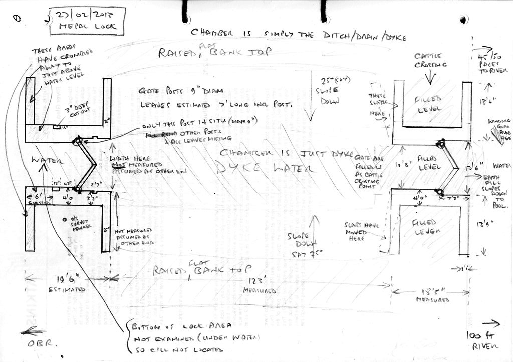
The lock chamber is much wider than the rest of the dyke and there is no evidence of any lining sugesting it had sloping earth sides as now. If that was the case I feel there would have been a danger of the lighters/barges grounding on the shallow edges and timber posts would have been necessary to keep them in the deeper central section but I haven't seen any evidence.
Update Dec 2016. Website visitor Chris Howes emailed to say that this unlined-lock is a "turf lock", similar to a couple on the Kennet and Avon Canal. Apparently the sides of such locks above low water level were turf-lined, sloping at 45 degrees, and below that the sides were planked vertically. Turf locks used a huge amount of water which would not have been a problem here as there was an abundant source from from the tidal New Bedford River.
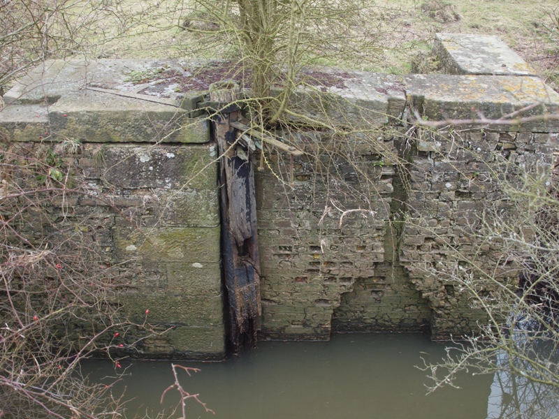 This is the east side of the north enclosure. Note: on left, an area cut out of the coping slab, approx 3" deep x 12"X18"; left of centre is the 'gudgeon-pin'
- the metal strap around the top of lock gate's main post; the anchor arms set into the top of the slabs
holding the gudgeon-pin; and right of centre, the brick-work in the gate recess has a verticle cut-out,
a narrow slot in the top half widening out to an inverted 'u' shape. All these features are replicated on the west side.
This is the east side of the north enclosure. Note: on left, an area cut out of the coping slab, approx 3" deep x 12"X18"; left of centre is the 'gudgeon-pin'
- the metal strap around the top of lock gate's main post; the anchor arms set into the top of the slabs
holding the gudgeon-pin; and right of centre, the brick-work in the gate recess has a verticle cut-out,
a narrow slot in the top half widening out to an inverted 'u' shape. All these features are replicated on the west side.
I assume the cut outs in the coping slabs were to locate a walk-way across the lock. The verticle recesses in the masonary housed the 'paddle' or 'slacker' gates (one on each leaf) and the winding gear that raised and lowered them enabling the the doors to be flush against the wall when open. All "Vee" or mitre gates have slacker gates which are opened when the gates are closed to allow water through to fill the lock but I've never seen this recess-within-a-recess arrangement before, and wonder why the whole recess wasn't made deep enough originally.
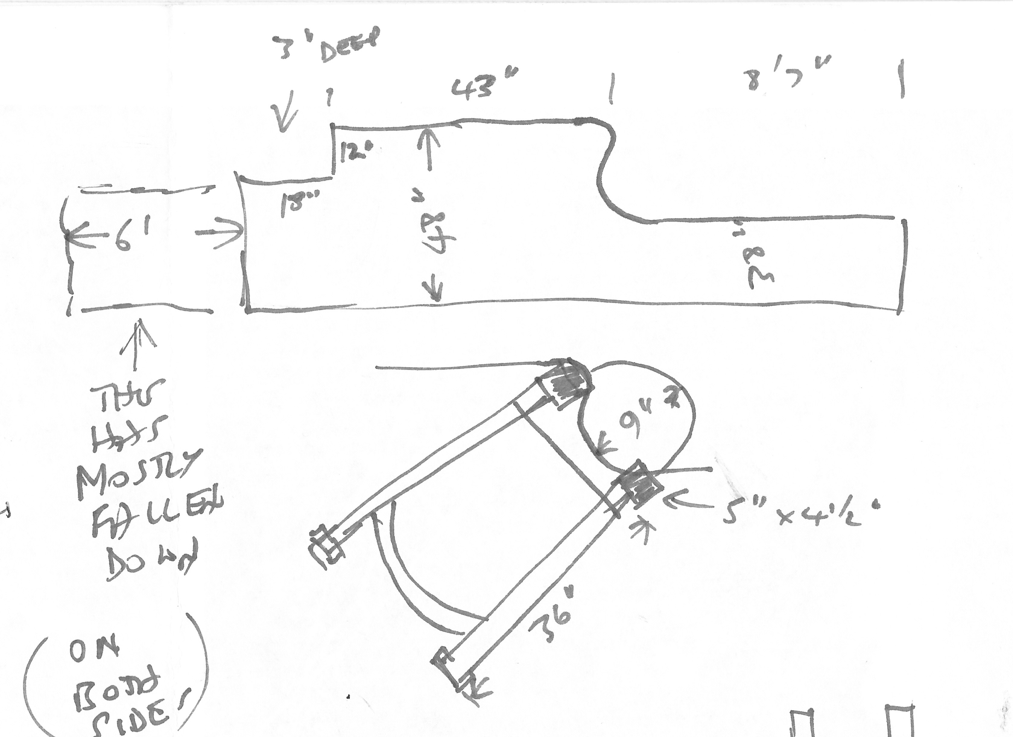 On right are my rough sketchs of the top of the lock gate enclosure, and the gudgeon pin
and anchor straps. Although shown separated, the 9" diam pin and anchorage sit on
the slabs.
On right are my rough sketchs of the top of the lock gate enclosure, and the gudgeon pin
and anchor straps. Although shown separated, the 9" diam pin and anchorage sit on
the slabs.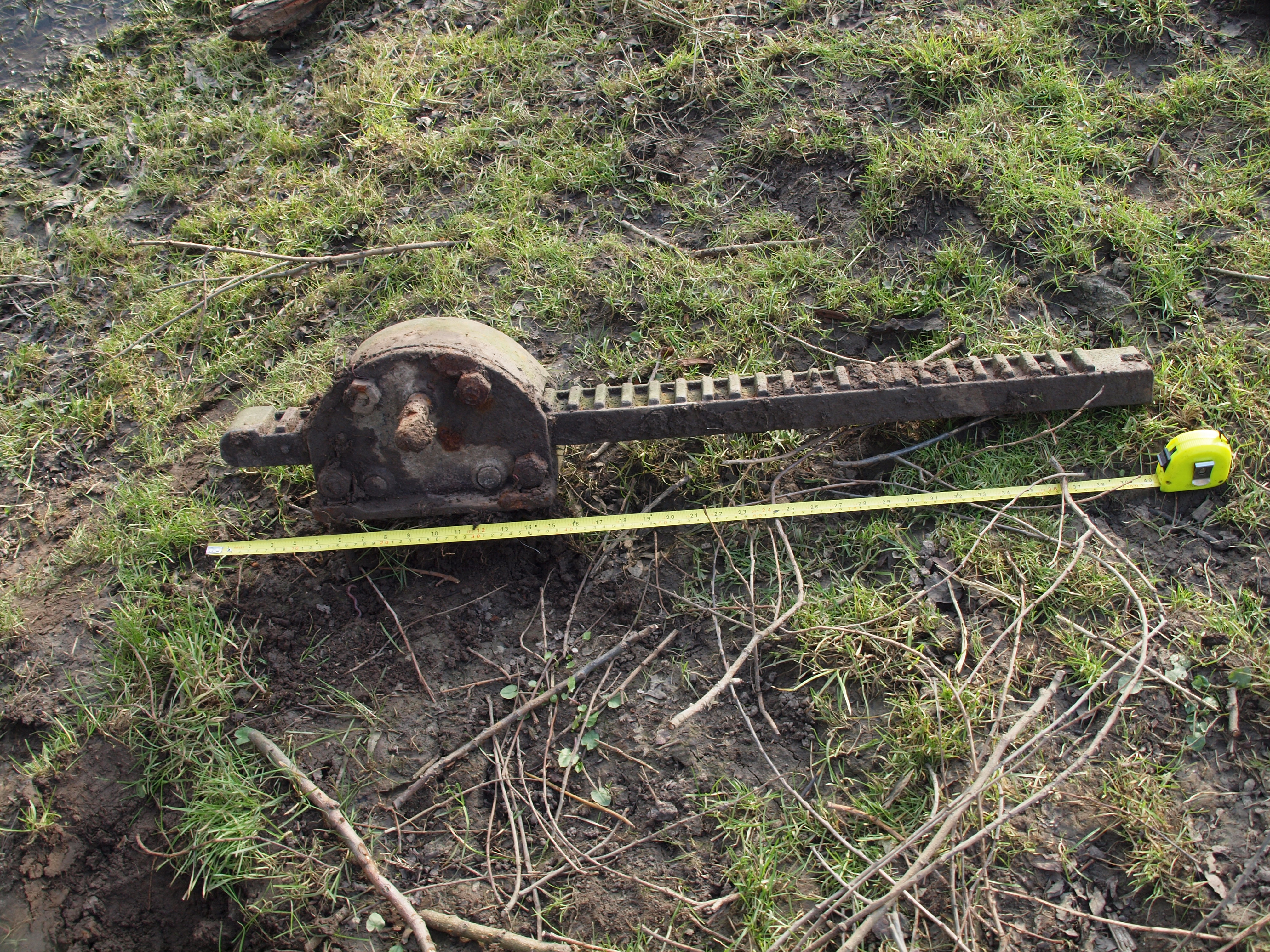 On left a piece of winding gear measuring 40" found loose on the ground.
We know from the petitions referred to above that the lock was added some time after the dyke was cut. It looks to me that the soil dug out during widening the chamber was formed into a raised bank around the lock giving the impression seen from a distance of an island. (see photo in introduction). The bank tops are not much below the present height of the cradge bank (the inner bank of the 100 Foot River).
I had planned to do a 'proper survey' later, but in the event I didn't need to because another website visitor put me in touch with a couple of Mepal residents who had done just that ten years earlier, in 2003 - Mike and Lorna Delanoy. Their meticulous measurements and Mike's detailed drawings are so good they could be used to re-build the gates. I was pleased that my own measurements for the length and width were virtually the same as Mike's.
As it is today (2017)
The northern end of the dyke still joins the OBR and water can flow along the dyke and into the lock right up to the southern gate enclosure which has been earth-filled to the top to provide a cattle crossing point.Beyond the southern end of the lock, the dyke continues as a water-filled pool for a further 50 yards or so up to the inner side of the cradge bank (which was built after the dyke was cut) so there is no longer a connection into the 100 Foot River.
The dyke now acts as a field drain, although I would guess with limited function, helping to clear floodwater off the washes into the OBR.
The northern gate still has the remains of the hinge beam of one gate leaf.
The two gate enclosures are of very similar dimensions, although it is difficult to be precise as parts of the structures have fallen away, particulary at the northern end.
I have dozens of photos showing details of the lock which will be added here later.
Maps
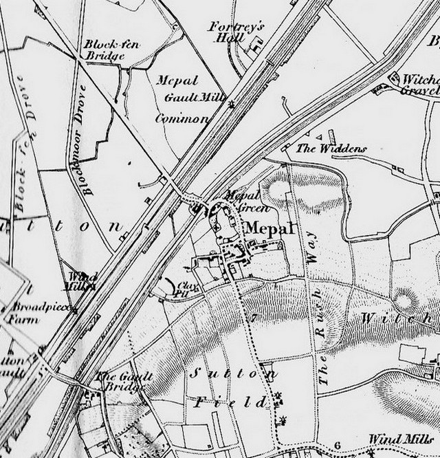
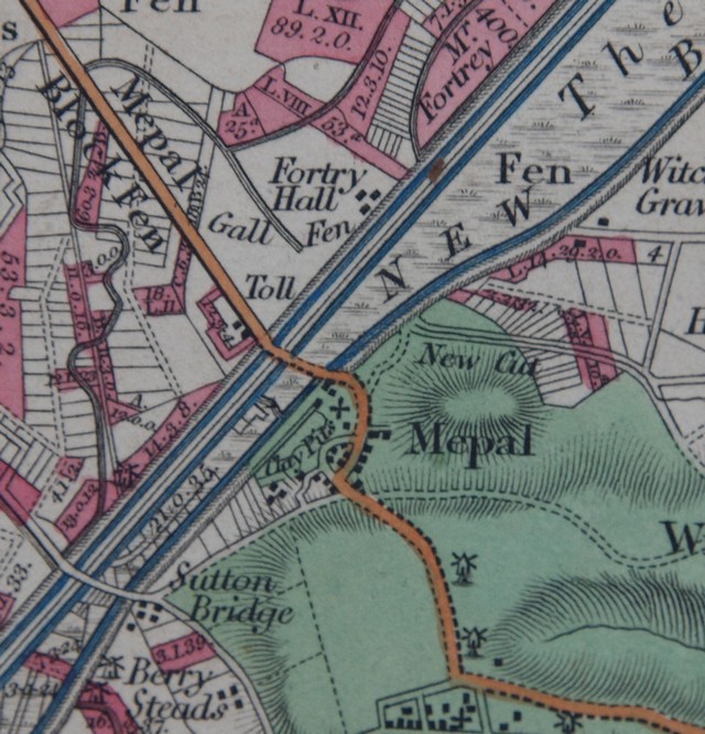 It's interesting to compare Samuel Wells 1829 ⅝" to 1" mile map with the Ordnance Survey (OS) 1"to 1 mile map published in 1836.
At first glance Wells map appears far superior to the OS one, and in many respects it is - apart from accuracy. Wells map has some oddities too, so that whereas both maps show the sluice (although differently aligned) only on Wells map is there the familiar symbol > indicating a lock. But Wells does not show that for locks anywhere else on his map, and the OS doesn't seem to have adopted that symbol until many years later. Strange.
(images: EE Jan 2013 from his collection)
 Comparing these
with later maps and satellite views
and aerial and ground level photos, shows the OS map is very accurate (as would be
expected). Wells depiction
of the road through Mepal is wrong, and he has omitted the buildings (including pub and
ferryman's cottage) on the wash side of the 100 Foot River to the south of the causeway
road.
Comparing these
with later maps and satellite views
and aerial and ground level photos, shows the OS map is very accurate (as would be
expected). Wells depiction
of the road through Mepal is wrong, and he has omitted the buildings (including pub and
ferryman's cottage) on the wash side of the 100 Foot River to the south of the causeway
road.If you click the maps and open the larger views in separate windows, you can resize them and have them side by side (dependent on your computer setup and monitor size) for comparison.
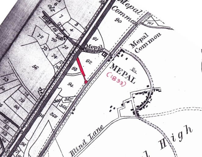 This crop is from a larger scale OS map from Mike Delanoy's collection. Mike has dated it 1833 and it shows the Dyke and lock which Mike has coloured red. If the date is correct the map opens up the debate about when the two gate structures were built.
 Note that the maps all show the main road across the washes in the position it was as a
causeway. In 1930 a viaduct was built just a little way north, and in 1984 that was
replaced by the current by-pass viaduct seen on the map in the page introduction.
Note that the maps all show the main road across the washes in the position it was as a
causeway. In 1930 a viaduct was built just a little way north, and in 1984 that was
replaced by the current by-pass viaduct seen on the map in the page introduction.
Later research and 2016 Exhibtion
An 'Ousefest 2016' event, the Mepal Great Dyke Exhibition at St. Mary's Church Mepal from Monday 18th to Sun 31st July 2016 tells the story of "Mepal's best kept secret".
The exhibtion was organised by Elizabeth Staziker (Churchwarden, vice-chair of Mepal Parish Council, trustee of Cambs ACRE and Chair of the Ouse Washes Landscape Partnership), with contributions from a very distinguished group including "Mepal people and sluice slueths" Mike and Lorna Delanoy; Dr. Nicholas James (Director of Studies in Social Anthopology at Magdalene College Cambridge and a consultant in Management and Interpretation of Historical Resources); and Kasia Gdaniec, Senior Archaeologist at Cambridgeshire County Council.
Displays at the exhibition include copies of archive documents, pieces of the limestone coping slabs, and information sheets that tell us that:
- The "great dyke of 12 foot river" was built by the Sutton and Mepal Commissioners, probably in the 1760s, to be shared with the Bedford Level Corporation (BLC), to create a route across the Washes for barges carrying gault to repair the barrier bank [the west, or north, bank of the Old Bedford River].
- In 1766, BLC had to ask the S&M Commissioners to remove stakes, to allow agreed passage for thie lighters.
- It was presumably closed originally by a staunch - a single gate.
- In 1805 some sort of lock structure was built.
- Some time in the 1830s [the lock] needed replacing. The structures seen today were built by BLC under the direction of John Owen.
An academic paper was completed in 2019 following extensive research over a number of years, latterly including the archives of the Bedford Level Corporation. It was published later that year in the journal of the Cambridge Antiquarian Society.

Led by Dr. James this may augment or update these notes and no doubt some of my own findings. At the time of my update of this page in January 2017 I was still unclear how barges could enter the Washes from the New Bedford/100 Foot River without a proper lock.
In Sept 2025 a short supplement written by Dr James was also published the the same journal. This followed further delvings into the BLC archives at their new home in Ely.
An event that was being considered was the rebuilding of the northern enclosure and gate. Mike Delanoy was trying to organise a works party and that the land-owners, RSPB, had given permission, indeed their blessing but sadly Mike died after the paper was published, and the works never happened.
The Great Dyke and the exhibition at the Church were featured in a short clip by Sue Marchant on BBC Radio Cambridgeshire during their afternoon show on Wednesday 27th July. You can hear the clip here.
If anyone reading this has any information, anecdotes, memories, photos or documents relating to this piece of "hidden heritage" please contact me or any of the people mentioned above.