

Earith Sluice
Page good for smart-phones. On PCs/Laptops it may look too large. To reduce press "Ctrl" & "minus" or click "View" then "Zoom out"
Created Mar 2013, last edited: 25/03/26, 15:03
Created Mar 2013, last edited: 25/03/26, 15:03
Introduction
March 2026 Page Upgrade
This page is under reconstruction following HTML and CSS code upgrades and changes from 2 or 3 columns to one responsive phone-friendly display.Inevitability, some images or text may be out of order or temporarily missing.
The reason for the sluice was, and still is, to divert some of the upstream waters of the Great Ouse River/Bedford Ouse into the Old Bedford River (and thence if necessary into the Ouse Washes) when flows are too much for the New Bedford River (the normal course to the sea) to cope with. In times of very heavy 'fluvial' flows, that is fresh water from upstream, "excess" water, (the amount that the New Bedford River and the downstream Great Ouse cannot handle) is diverted into the Old Bedford River via Earith Sluice on the left of the photo. The sluice operates automatically when the river level reaches a pre-determined figure. The Old and New Bedford Rivers run more or less parallel north east for about 20-21 miles, and the land between them is the flood plain known as the Ouse Washes. The excess water flows from the Old Bedford into the washes and is held until tidal conditions allow discharge.
Scroll down to follow the story or choose a section to jump to from the drop-down menu.
1652, Nine Holes Sluice
According to Dugdale's, History of imbanking and drayning of divers fennes and marshes, 1772 edition, p 410 (quoted by HC Darby) the Bedford River (the original name of the Old Bedford River) had:"at each end thereof a sluice of great strength" and "a great sasse [i.e. sluice or lock] on Well Creeke, with a stone sluice at Salters lode, upon Bedford River, to keep out the tides; and sluices at Erith [sic] for the fresh".Many writers since have assumed that the above meant that the Bedford River had a sluice at each end when Sir Cornelious Vermuyden had the drain cut in 1632-37. However, as his intention was that it would be the main channel towards the sea he would surely have wanted an unimpeded entrance.
Also, Dugdale didn't visit the fens until 1657, five years after the New Bedford River had been cut to replace the first Bedford River as the normal course towards the sea. A sluice would certainly have been needed at the start of the Old Bedford then to block it off except in times of high flows which his New Bedford River couldn't handle. I therefore suggest that Nine Hole Sluice was built about 1652. But no references I've read confirm that.
We do know when it was demolished - 1824 - because it was replaced then with the Seven Holes Sluice (and bridge), below.
1824, Seven Holes Sluice
Built in 1824 to replace the original Nine Holes Sluice. According to Summers (The Great Level, p179), this was built by the Hundred Foot Washes Commissioners. (also quoted by Prof HC Darby).The Earith Parish website records these works as 1812, which I believe is incorrect.
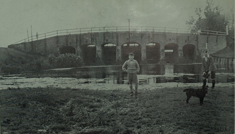
Photo: Reid Collection, C.A.S. (from The changing Fenland, Darby, 1983) from downstream
The boys and the dog are standing in the Old Bedford River. Earith village is to the right. Note left bank, the Washes side, is much lower than the village side.
A report by GGG Wheeler in both the Hunts Post and Peterborough Standard in 1927 referred to the Land Drainage (Ouse) Provisional Order, 1920, which set up the Ouse Drainage Board that replaced the Bedford Level Corporation in 1920. Mr Wheeler said that one provision in the 1920 order was that from April to October inclusive the gates at Earith "shall not be fully drawn until the water on the upper side of the structure is 13.9 feet" AOD, "and from November to March two feet [0.61] below that".
I have not been able to establish whether the levels shown and the seasonal differential were inherited or were new ideas.
Note that in 1920 the ordnance datum point was Liverpool, and these figures need conversion to equate to post 1920 figures based on Newlyn.
For an explanation of Ordnance Datum and datum points, see my water levels page.
The 1920 order was to be replaced with a new bill in 1927 in which a new sluice was to be built with gates height set at the discretion of the Board. That Bill did not become law, but another did, in 1930, see next section.
Seven Holes Sluice was demolished in 1954.
1954, Earith Sluice (Three Holes Sluice)
Built by the Great Ouse River Board (GORB) to replace the 1824 Seven Holes sluice, the 3-gate stucture was erected just upstream (south) of the 1824 sluice (i.e. on the other side of the sluice shown above).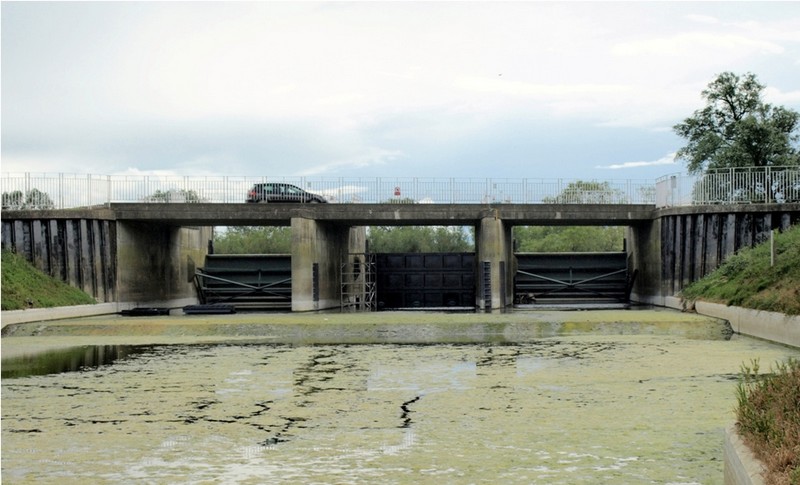 Photo: Peter Cox, May 2011, seen from downstream, in the almost dry Old Bedford River.
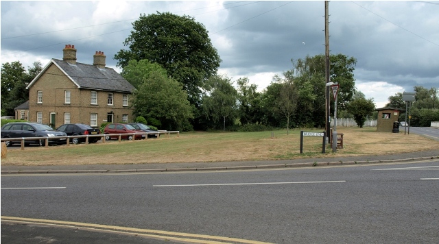 That can be seen by the position of Bridge House (left, Photo: Peter Cox, May 2011) today. The
road would have run just in front of it, now it's quite some distance. (click photo to see that more clearly).
That can be seen by the position of Bridge House (left, Photo: Peter Cox, May 2011) today. The
road would have run just in front of it, now it's quite some distance. (click photo to see that more clearly).The sluice has three radial gates, each 6.71m [22ft] wide (OW WLMPs, 1996-2002). Operation is automatic - between April and October, opening begins when the level in the Bedford Ouse reaches 3.77m AOD, and closes at 3.72m AOD. The November to March levels are 3.17 and 3.12m AOD. The centre gate opens earlier and closes later than the outer gates.
The opening levels are known as "drawmarks", and many writers say they were set by the Land Drainage Act of 1930. However, one reliable reference - the London Gazette - in 1976 cited The River Great Ouse Catchment Board Transfer Order of 1931 [which may in deed have been an order under the 1930 Act] setting the level at which the "Seven Holes Sluice (sometimes known as the Three Holes or Earith Sluice)" operated [ie, opened] at 13.9 feet [above] "OD Liverpool" or 12.5 feet [above] "OD Newlyn". The latter equates to 3.81m AOD, but the Ordnance Survey's current conversion from Liverpool to Newlyn makes the figure 12.6 feet, or 3.84m AOD. Compared with todays figures the difference may seem small, but spread over nearly 6,000 acres it is quite significant, and it seems to me that the current levels must have been set post-1976, but when and why?
It is also interesting that the figures quoted in the 1931 order seem to go back to at least 1920 as can be seen from Mr Wheeler's comments in the previous section. Mr Wheeler also quotes a winter level 2 feet [0.61m] below the 13.9 ft summer mark. That differential is virtually the same today.
For an explanation of Ordnance Datum and datum points, see my water levels page.
One of many recommendations of The Great Ouse Tidal River Strategy report (GOTRS) in 2009 was raising the winter drawmark to 3.77 [same as the summer figure] which would mean less water going down the Old Bedford and into the Washes. The benefits would be less likelihood of flooding of the A1101 Welney Wash Road and the increased flow on the New Bedford River/100 Foot Drain would help to scour the river reducing silt build-up. However there were numerous objections to the report and the lower winter drawmark remains.
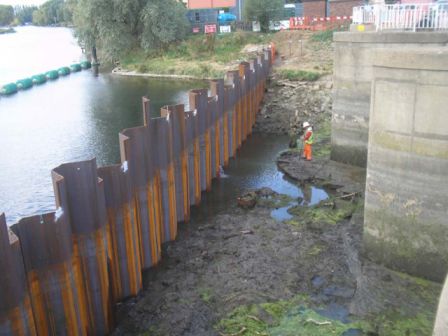
Photo: Peter Cox, May 2011.
2009 WORKS
By Team Van Oord Aug-Oct. Refurbishing concrete platform that sluice stands on & installing new anchor piles to support the sluice structure.
A cofferdam installed upstream to enable works but at a level that will allow flood water to flow over it and the sluice function as normal.
Note:Team Van Oord is partnership between Van Oord, May Gurney and Mackley
A cofferdam installed upstream to enable works but at a level that will allow flood water to flow over it and the sluice function as normal.
Note:Team Van Oord is partnership between Van Oord, May Gurney and Mackley
2010 WORKS
By Team Van Ord Apr-Oct.
Estimated cost £508,000 Improvements to mechanical and electrical parts of the sluice. Replacing
gate lift ropes, winches and hinge pins; refurbishment and repainting of the three sluice gates. Work on one gate at a time which will be dammed off.
Other two gates remain operational.
Refurbishment works, 2009-2012
In 2009 a refurbishment programme started to ensure an increase in service life of 25 years, but the EA gives very litle detail about it on their website. See panels on left for 2009-10 works. Source "Ryan Ely", EA Project Manager).When I visited the sluice on 26th May 2011 there were signs that work was being carried out on the centre gate hoist ropes and/or motor, but no signs of any workers. Nothing to be found on the EA website either.
I did however find a letter from the EA on the Earith Parish Council website. It was undated but must have been late 2010. It said the centre gate had been reinstalled & tested, and the contractors would leave by 3rd December [2010]. The letter summarised the works during the year 2010:
- Damboards and fixings have been delivered to our Ely depot for both the upstream and downstream sides of the sluice.
- The control building has been underpinned preventing further subsidence.
- The redundant water transfer system below the centre sluice gate has been removed.
- New hinge pins have been fabricated for the sluice gates.
- The electrical wiring to the sluice gates from the control building has been upgraded.
- Pumps have been designed and purchased for the counterweight chambers to keep these chambers dry.
- New covers have been installed on the counterweight chambers in the sluice piers.
- New lifting ropes have been installed on the centre sluice gate.
- The centre gate was removed, surveyed, minor repairs undertaken and reinstalled.
- A new telemetry system and new actuators will be installed over winter
He also said the link path at the picnic area will go ahead as planned in early January [2011?]. I didn't see that when I visited in Apr 2012.
The centre gate was removed in 2011 (replaced by temporary steel damboards) and re-fitted after repars..
Acknowledgements
Text and photos except where noted © Peter Cox, 2010-26If you think there are any errors or ommissions on this page or would like to comment, please e-mail me and your response will be added.