

Denver Sluice
Page good for smart-phones. On PCs/Laptops it may look too large. To reduce press "Ctrl" & "minus" or click "View" then "Zoom out"
Created Mar 2013, last edited: 25/03/26, 15:03
Created Mar 2013, last edited: 25/03/26, 15:03
Introduction
March 2026 Page Upgrade
This page is under reconstruction following HTML and CSS code upgrades and changes from 2 or 3 columns to one responsive phone-friendly display.Inevitability, some images or text may be out of order or temporarily missing.
Subsequently, I learned that its owners, the government super-power, the Environment Agency, considered it to be of such vital importance that they allowed it to seize up. When criticised by motorists for flooding roads, by anglers for killing fish, by conservationists for drowning birds and by boaters for preventing navigation, they, the almighty EA, spent millions of pounds of our money on consultants who said "unseize it, make it work again; and if you pay us, the fat-cat consultants, more millions, we'll tell you how." Well, that was the talk in the pubs, on the river banks, in the boatyards and bird hides. Was I missing something? Shouldn't they, the all-knowing EA, have known to do that, and how to do that, and spent the money doing that?
In fact, I discovered during my investgations in 2012-2015, that after dozens of expensive consultants reports, and enough money paid to civil enginneers to cover the Welney Wash Road several feet deep, it mostly does work, at least when circumstances permit. And when that is the case, Denver Sluice controls the flow from the non-tidal branch of the Great Ouse River known as the Ely Ouse, or Ten Mile River, into the tidal reach of the Great Ouse River known locally as the Tidal River, at a point just above where the New Bedford or Hundred Foot River joins the Tidal River. It should be noted that Denver Sluice also prevents the tide going up the Ely Ouse, overflowing its banks and flooding the low lying land much of which is below sea level. I've also discovered that there are many occasions when circumstances do not permit. Rain, tides and silt, for instance. Especially the latter.
Another thing I've learned is that one small sluice doesn't have much street cred in the drainage world. So, over the years, four more have sprung up nearby directing water hither and thither, and to emphasise how difficult it all is it to manage, they've named the whole site "Denver Complex". None of the five sluices are geographically within the Ouse Washes, but they are major players in the operation and management of the Washes, and all the main structures of the Washes are controlled by EA staff based at the Complex.
Scroll down to follow the story or choose a section to jump to from the drop-down menu.
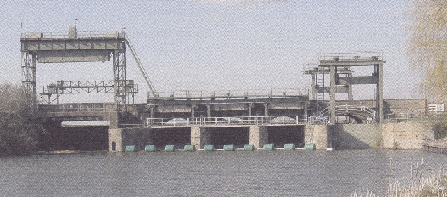
The sluice and lock(s) c2006, seen looking north from the Ely Ouse/Ten Mile River.
Left to right: The "Big Eye" (a sealed-off sluice/navigation gate for large commercial vessels); the "little eyes" (the three sluices); and the navigation lock. (Photo: EA)
Chronology of main events
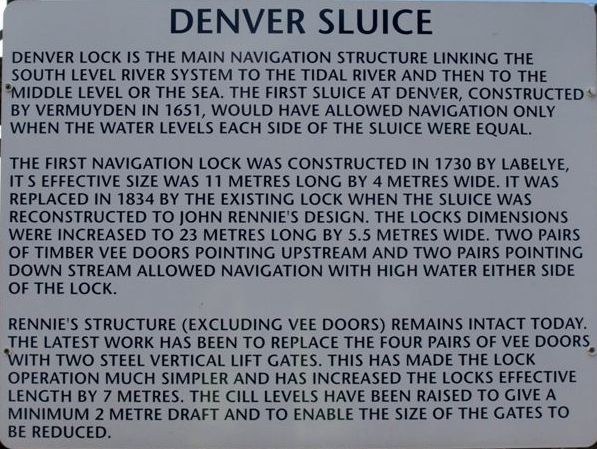
The most reliable accounts I've read of the history of Denver Sluice (indeed of all drainage of the Cambridgeshire Fens) are, in publication date order, Samuel Wells, The History of the Drainage of the Great Level of the Fens called Bedford Level, Vols 1 and 2, 1830; Prof. HC Darby, The Draining of the Fens, 1956; Dorothy Summers, The Great Ouse, 1973 and The Great Level, 1976; and Prof Darby (again), The changing Fenland, 1983 (a revised and extended version of his earlier work). All are in my personal library. I'll refer to them below simply by surname.Information on a signboard displayed at the sluice is generally helpful but I believe would be better if imperial measurements were shown followed by metric equivalents in brackets. Imperial was used by the engineers/builders listed and by most of today's older population who make up the vast majority of visitors.
 Also, some data differs from that summarised by Darby as shown below ("fig117")
I've noted the differences in the table following. Some minor variances in the years may be due to use of start or finish dates but Darby's date for the rebuilding by Labelye in 1750 is suported by others, including Wells and Summers and I believe can be taken as correct.
| event | year per EA sign |
year per Prof Darby |
engineer/designer, features |
| Built | 1651 | 1652 | by Sir Cornelius Vermuyden. Badeslade's map shows 1651 |
| Improved | not mentioned | 1682 | |
| "Blew up" | not mentioned | 1713 | all 3 little eyes washed away; South Level flooded by tides. |
| rebuilt | 1730 | 1750 | by C Labelye Navigation lock added, 11m x 4m |
| reconstructed | 1834 | 1832 | by John Rennie New lock, 23m x 5.5m, with 4 sets of mitre gates, 2 pointing upstream, 2 downstream, allowing navigation regardless which side had highest level. |
| enlarged | not mentioned | 1923 | new navigation gates added, named "Big Eye" |
| lock changes | not mentioned | post Prof Darby's book | small navigation lock Vee doors replaced with 2 x VLGs, increasing length by 7m [to 18m?] |
Vermuyden's 1651 Dam and Sluice
In 1651 Vermuyden created what we now now call the Ouse Washes, i.e. the Hundred Foot Washes, by cutting a new channel, the Hundred Foot Drain (aka New Bedford River) from the Great Ouse at Earith to re-join the Ouse between Salters Lode and Denver, more or less parellel to the 1630s cut which became the 'Old' Bedford river. Unfortunately the bed of his new channel where it rejoined the Ouse was higher than the old course, so incoming tides flowed up the the Ouse towards Ely frequently overflowing into the adjacent low land. To overcome that, he put an earth dam across the old course near the junction with the new cut, and constructed a lock nearby to allow both drainage and navigation. It was almost universally condemned, making navigation difficult and at times impossible, and allowing the river downstream to silt up through lack of scouring.Darby says Vermuyden's lock had a "24-foot waterway". Wells, Vol 1, pps 739-740, refers to the earth dam and "two small brick sluices" and Oscar Borer, (The Cambridge Region, 1938, p200) said a new lock in 1923 "replaced two smaller sluices". I therefore suggest that the 24 foot waterway was in fact two 12-ft sluices, or locks.
Noted engineer Thos. Badesdale drew plans of the sluice in 1725 one of which he dated 1651 showing five sluices. From the accounts above the date must be wrong, see next section.
1682 improvements
 Wells says "In the year 1682, various alterations were effected in the
formation of the sluice : three brick arches were set down where the clow or dam
stood: the middle arch was made 18 feet, and the two others 12 feet wide : doors
were formed in each arch, capable of being taken off or set open to let in tides
; and it was conceived, that these expedients would allow a much better
water-way than formerly ; and that a greater facility would be afforded to
navigation, than existed before the erection of the original dam or sluice."
Wells says "In the year 1682, various alterations were effected in the
formation of the sluice : three brick arches were set down where the clow or dam
stood: the middle arch was made 18 feet, and the two others 12 feet wide : doors
were formed in each arch, capable of being taken off or set open to let in tides
; and it was conceived, that these expedients would allow a much better
water-way than formerly ; and that a greater facility would be afforded to
navigation, than existed before the erection of the original dam or sluice.", but. One shows what he considered the structure in 1651 - the two sluices mentioned above and three more where the earth dam had been. I feel that is more likely to have been A second plan, which he says is what remained of the sluices after the tides "blew them up" in 1713, shows the brickwork remains of the two sluices
1713 - Sluice collapsed
 In 1713, violent tides rushing up the river "blew-up" the sluices which previously had been weakened by floodwaters coming down
and undermining the upstream foundations. The minutes of the Bedford Level Corporation (BLC) record that members met at Denver in July and found it close to collapse, but by then it was too late to repair.
In 1713, violent tides rushing up the river "blew-up" the sluices which previously had been weakened by floodwaters coming down
and undermining the upstream foundations. The minutes of the Bedford Level Corporation (BLC) record that members met at Denver in July and found it close to collapse, but by then it was too late to repair.
Darby also refers to Thomas Badeslade writing in 1725 that after the undermining from upstream, the sluice was "blown up" by incoming tides. Badesdale also stated that without the sluice, the New Bedford/ Hundred Foot River then turned towards Ely instead of flowing to Kings Lynn, which Badesdale says could have been prevented if the Hermitage Lock at Earith had been opened as soon as Denver Sluice collapsed to allow the Ouse to flow along its old course to Denver.
Labelye's 1750 Sluice and Navigation Lock
This was a great improvement, with wider waterways, lower foundations, and a proper navigation lock on one side.Rennie's 1834 Sluice and lock
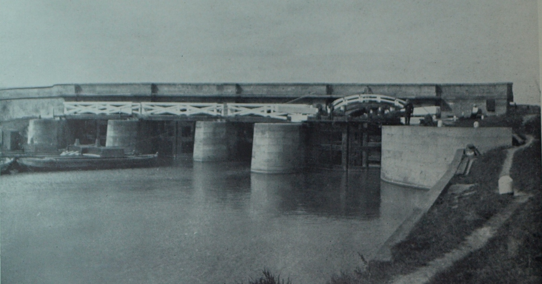
Seen in 1923 from upstream just prior to the 1924-5 works
(photo: Camb. Antiq. Soc., shown as plate 9 in HC Darby's book)
Note: the little eyes have mitre gates upstream as well as downstream and both sets open away
from the sluice; the white painted timber
walkways over the litle eyes of an 18th century pattern seen throughout the area ;
an arched timber walkway over the navigation lock; the brick parapet of
the road across the sluice; and the lighters
on left - are they steam driven? 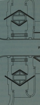 The lock arrangement allowed for the fact that unlike canal locks (which always
have water levels lower on only one side and the lock gates pointing downstream)
this lock may have lower water either side, so it had four sets of mitre gates
allowing operation regardless of levels.
The lock arrangement allowed for the fact that unlike canal locks (which always
have water levels lower on only one side and the lock gates pointing downstream)
this lock may have lower water either side, so it had four sets of mitre gates
allowing operation regardless of levels. 1923-25 enlargement and improvements
The works included replacement of the upstream mitre gates of the little eyes with lift gates and adding a metal walkway above the wooden one for access to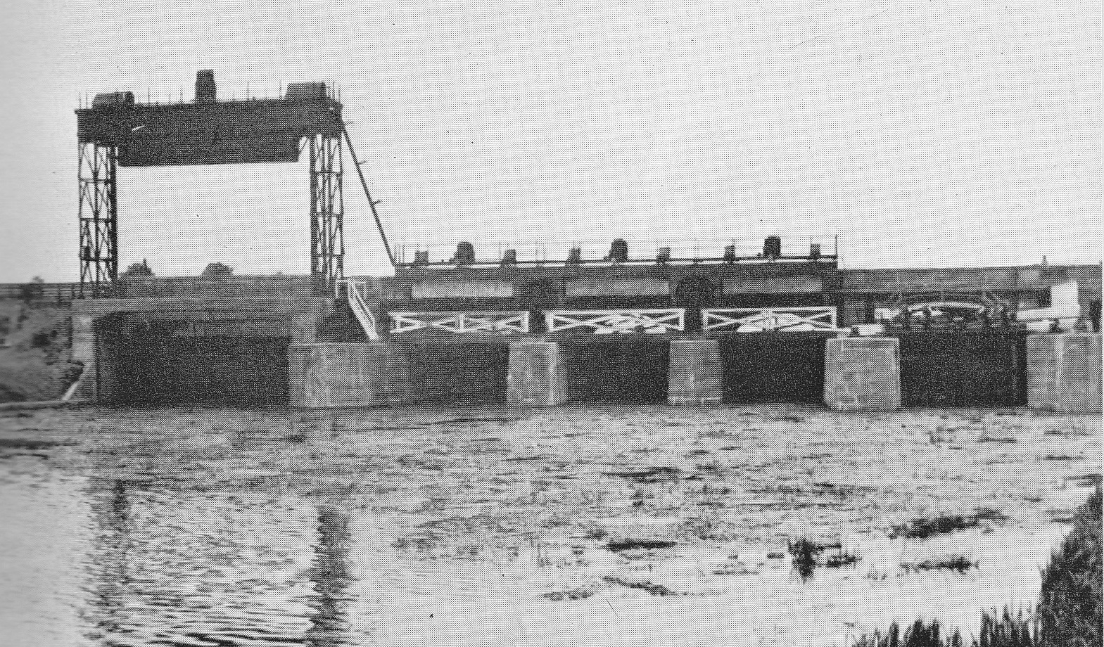 the lifting gear.
A new feature was a "Big-Eye" (on the left) for navigation. Seen from upstream c1924-25 (Photo from The Great Ouse, Dorothy Summers, 1973) with what appears to be a single lift gate. This was said by the Chief Engineer of the RGOCB, Oscar Borer, (The Cambridge Region, 1938, p200) , to be 34ft wide and replaced two smaller sluices. Presumably for commercial craft too wide or high for the lock on the right.
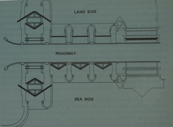 This c1938 photo (from: HC Darby, The Changing Fenland, fig.52) and 1923 plan below, also from Prof Darby's book, but flipped
to correspond wth the photo, both show the big eye with two lift gates making it a proper lock with navigation possible regardless of tide, but
as the gates are only 50 ft apart, only for short vessels, or, say, 3 lighters side by side. The downstream gate appears to be slightly
raised (?).
This c1938 photo (from: HC Darby, The Changing Fenland, fig.52) and 1923 plan below, also from Prof Darby's book, but flipped
to correspond wth the photo, both show the big eye with two lift gates making it a proper lock with navigation possible regardless of tide, but
as the gates are only 50 ft apart, only for short vessels, or, say, 3 lighters side by side. The downstream gate appears to be slightly
raised (?).On the plan, all the doors and gates are shown solid black except the downstream gate of the Big-Eye (top left).
Perhaps the second gate was planned in 1923 but not installed until later, which would account for the differences in the photos.
1982-86 Re-furbishment
 This is referred to as an "event" in figure 4-1 on page 25 of the September 2009
EA document Great Ouse Tidal River Strategy Review, SEA Environmental
Report but no details are given. However, we do know the vee-doors/gates
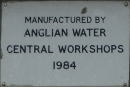
of the lock were replaced with guilotine vertical lift gates because one of the
EA's predecessors thoughtfully and proudly affixed
plates to them. So far to I have found no earlier reference to changes to Rennies 1834
gates - surely they couldn't have lasted 150 years?
This is referred to as an "event" in figure 4-1 on page 25 of the September 2009
EA document Great Ouse Tidal River Strategy Review, SEA Environmental
Report but no details are given. However, we do know the vee-doors/gates
of the lock were replaced with guilotine vertical lift gates because one of the
EA's predecessors thoughtfully and proudly affixed
plates to them. So far to I have found no earlier reference to changes to Rennies 1834
gates - surely they couldn't have lasted 150 years?2008 Little Eye inspection & repairs, and de-silting
In 2006, nearly 15 feet of silt was against the downstream "V" doors of the little eyes, preventing them from opening, The EA say it was because of sluggish river flows [from upstream] in the dry winters of 2004-5 and 2005-6. Others claim it was because the Ely Ouse had been allowed to discharge through the relief channel rather than through the sluices and the EA had not bothered to clear the silt, which builds up anyway because of the nature of the Tidal River.Temporary barrier gates known as stop-logs or damboards were placed in front of the eyes, and the gates checked. Below, one eye is now working (although closed), the other two are still closed off.
(Photo: EE, July 2008)
The EA said various air and water jetting systems were being considered to keep the doors clear of silt in future, and trials may begin next year.
In fact, pipework for air blasting the silt was in place in Dec 2008, see right.
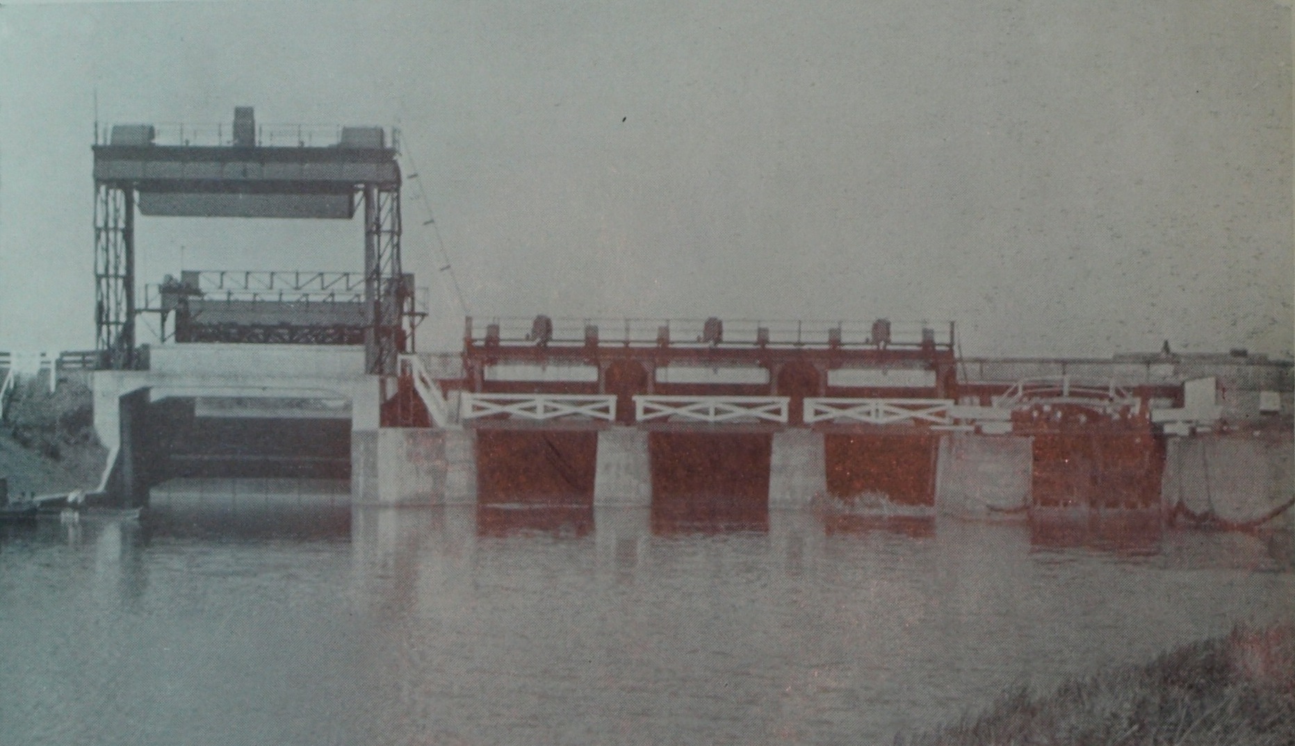
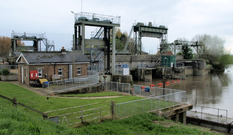
current arrangement
The current view from upstream, with the navigation lock's 2 lift gates. The timber walkway seen in the earlier photos has been replaced by metal, and the Big Eye has lost its downstream gate, replaced by a concrete slab.
(photo: EA, c2006)
(photo: Eddy Edwards, 2012)
Left to right, upstream guillotine lock gate, lock keepers office, downstream guillotine lock gate, three little-eyes (one hidden), the unused big-eye upstream guillotine gate with counterweight raised, the green cabin on the far little eye controlling the the de-siltting/jetting equipment on the little eye vee doors, the downstream big-eye downstream structure with gate & counterweight removed and blocked off with a concrete slab, and the Hundred Foot river joining the Ouse "tidal river".
Operating rules
Rules were set out in the draft Ouse Washes Water Level Management Plan of 2002. I have not been able to get the EA to tell me whether that plan has been adopted, or superceeded - I can't believe it hasn't - so details below may be incorrect, and no doubt are subject to lots of ifs and buts, including the effects of drought and siltation.The rules set target figures for river levels at various places. Denver Sluice has three sluice outlets and any combination of the three can be used to achieve the targets. The outlets are known as "little eyes"; each has a vertical lift gate at the upstream (u/s) south end and a set of mitre gates at the downstream (d/s) north end pointing into the Tidal River.
Operation is by raising the upstream lift gate when tidal conditions downstream will allow the mitre gates to open under gravity, ie upstream pressure, when the tide is low enough - and if silt isn't blocking the mitre gates!
The sluices are monitored and adjusted by resident sluicekeepers.
If necessary, the slackers on the navigation lock can be opened to increase discharge.
All figures are AOD.
"Winter" 1st November to 31st March.
- Denver Sluice to be used for all discharges.
- Try to maintain Ely Ouse levels of 1.5m at Ely and 1.22 to 2.13m immediately u/s.
- Cut-Off and Relief channels should not normally be used.
- Anticipate floods. Use Denver to reduce levels in South Level in advance to maximise storage
- Cut-Off Channel to be held at -1.0m (using Impounding Sluice) and Relief Channel at -1.0m.
- Cut-Off and Relief Channels may be used in conjunction with Denver Sluice if the above level limits cannot be maintained
- Close Denver during flood peaks and maximise Welmore Lake Sluice discharge to minimise flooding of Welney causeway.
"Summer" 1st Apr - 31st Oct
Washes NOT flooded (Welmore Lake u/s level less than 0.9m AOD)
- Denver Sluice is to be used for all discharges.
- Try to maintain Ely Ouse levels of 1.6m at Ely and 1.37m to 1.7m immediately u/s.
- Cut-Off channel to be held at -0.2m using Impounding Sluice
- Cut-Off and Relief Channels may be used to relieve local flooding from Wissey, Little Ouse and Lark rivers, PROVIDING level in Cut-Off Channel is not allowed to exceed -0.2m at the Impounding Sluice for more than 24hrs in a 72hr period.
- Flow through Residual Flow Sluice must not exceed 6m3/secs
Washes FLOODED (Welmore Lake u/s level exceeds 0.9m AOD)
OR Offord discharge exceeds 30 cumecs.
- Denver Sluice should be closed, provided soil moisture deficit greater than 50mm.
My comment
So, there you have it. The draft 2002 WLMP has over 60 pages, and just once "Offord" is mentioned, a single word in a sub-title of the Denver operating rules as shown above. It is not explained, nor is it in any other EA publication I've found. Yet what happens there can determine whether Denver Sluice should be open or closed. My assumption is that even if the Washes are not flooded, they will be soon if the river flow at Offord (near St.Neots) is above the figure stated.Just as strange is the mention of "soil moisture deficit". I wonder what that is, and where it is tested?
Great Ouse Flood Protection Scheme 1953-1964
Vermuyden was concerned about flooding in the South Level and suggested remedies in his famous 1642 "Discourse". One was to drain the Ely Ouse into the Tidal River more quickly than Denver Sluice and the upper part of the Tidal River could manage. This he dealt with it in the 1650s by cutting a new channel named Downham Eau or St. John's Eau, from Denver, but by-passing the sluice, running along side the Tidal River to Stow Bridge. I assume it joined the Tidal River there, but have never found evidence in books or maps of how it did so.His other idea was to join the main South Level rivers which he refered to as "Mildenhall", "Brandon" and "Stoke" (i.e. Lark. Little Ouse and Wissey) to a new cut to skirt the fens and join the Great Ouse at Denver rather than flowing individually into the Ely Ouse.
Three hundred years later, those two ideas were the basis of a £10 million scheme to relieve flooding in the South Level. Two new channels, the "Flood Relief Channel" and the "Cut Off Channel" were dug to carry and store excess flows which those four rivers could not hold or Denver Sluice handle. Work began in 1953-4 and was completed after 10 years.
(Flood) Relief Channel
This was cut during 1960-61. It starts from a cut off the Ely Ouse immediately south of Denver Sluice running in Vermuyden's 1650s drain along side the Tidal River to Stow Bridge then in a new cut to Kings Lynn. Flows are controlled by the AG Wright Sluice, known as the Head Sluice, on the northern edge of Denver Complex, and the Tail Sluice where the channel joins the Tidal River at Saddlebow, Kings Lynn. The Ely Ouse can therefore be discharged into the Tidal River via Denver Sluice or diverted into the Relief Channel and held until tides allow discharge via the Tail Sluice.The AG Wright, or Head, Sluice
The AG Wright Sluice is of reinforced concrete and has three openings, each with a vertical lift gate (VLG) 30ft wide.Tail Sluice
The Tail Sluice has seven openings, each with an u/s VLG and a d/s steel flap gate 30ft wide x 22 ft high.Cut Off Channel
This was started in 1953, and runs 27½ miles from a head sluice (constructed 1960?) on the R Lark at Barton Mills to the Relief Channel immediately north of the AG Wright Sluice, originally unimpeded but later via the Impounding Sluice at Denver Complex.It runs under the Little Ouse at Hockwold-cum-Wilton, and under the Wissey south of Stoke Ferry, and can take excess water from both via sluices, all much as Vermuyden suggested.
other sluices at Denver
There are two other, the Diversion Sluice, and the Residual Flow Sluice.(Details to be added)
There is also a relief channel lock enabling navigation from the Ely Ouse into the Relief Channel. This is not as I read somewhere a lock added to the AG Wright Sluice, but built into a cut between the relief channel u/s of the AG Wright lock, into the Cut Off Channel d/s of the Impounding Sluice, thereby by passing the AG Wright Sluice.
Water Level Gauge Boards
References
Acknowledgements
Text and photos except where noted © Peter Cox, 2010-26If you think there are any errors or ommissions on this page or would like to comment, please e-mail me and your response will be added.