The
|
|
Welcome to my independent research project on
at
- Contents of this page
- related pages on this site
- related pages on other sites
- Home page and full site index
- Recommended OS Maps
- Site designed and written by
Peter Cox 
- page created: 30 May 2011
- last updated: 26 Nov 2021
- Please "refresh"/"reload" page
Your computer stores images of webpages you visit in a "cache". When you re-visit, the stored page may be displayed. To see if it has changed, click the "refresh" or "reload" icon at top of screen. Designs/colours vary, examples:


- Copywright, acknowledgements
- Can you correct/add anything?
| The Ouse Washes Website Welmore Lake Sluice |
Please note:
Many of the watercourses, sluices and roads in this area have multiple names, or variations in style.
Some (but not necessarly all) alternatives are shown here.
Some (but not necessarly all) alternatives are shown here.
Welmore Lake Sluice - the end of the Ouse Washes floodwater reservoir
Introduction
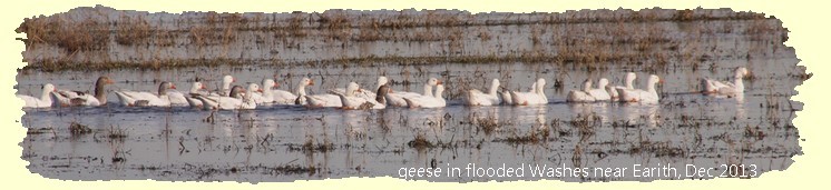
Welmore Lake is not marked on maps, but Welmore Lake Sluice is. The sluice is at the end of the Delph River, at the most northerly and downstream part of the floodwater storage area on the Ouse Washes. It is the only means of discharging flood water ("evacuating" is the official term) from the Washes into the tidal Hundred Foot/New Bedford River. It is accessable by public only by boat or a long walk, the latter being accomplished by me from Salter's Lode.As you may have have gathered from my previous pages, heavy rainfall in Bedfordshire can result in more water than the Great Ouse River can carry to the sea without overflowing one of more of its branches. When the river height reaches a certain level at Earith, some 19 miles south-west of Welmore Lake sluice, excess water is diverted automatically into the Old Bedford River, which from Welches Dam becomes the River Delph.
If the Old Bedford/Delph Rivers cannot cope, the waters flow over the rivers eastern banks into the washes. The water then flows through the washes, over the A1101 Welney Wash Road (which the EA calls "Welney Causeway") often making the road impassable, and is held by the sluice until It can be discharged into the tidal Hundred Foot/New Bedford River by gravity through the sluice when levels in the tidal river are low enough to permit the gates to open.
Background and 1756 Dam
When Vermuyden created the Ouse Washes in 1652 (by cutting the Hundred Foot Drain or River (HFR), aka New Bedford River (NBR), running more or less parallel to his earlier cut, the (Old) Bedford River (OBR), and by so doing creating a flood plain or reservoir between the rivers) the "outlet" for the stored floodwater was via the Old Bedford Sluice at Salter's Lode.About a 100 years later, a third river, the Delph, was cut from Welches Dam runing alongside and to the east of the OBR for several miles then crossing the washes to join the New Bedford (see maps below).
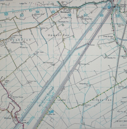
|
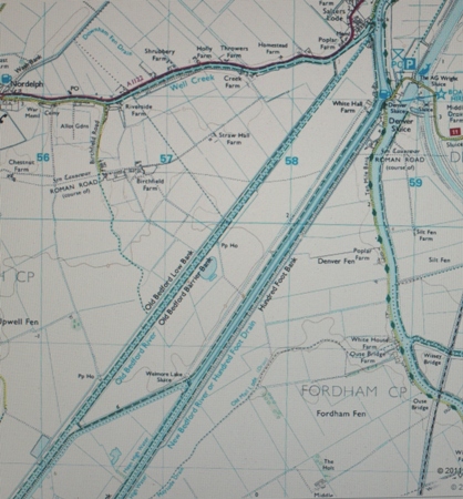
|
| the washes from Welney to Salters Lode | the washes from Welmore Lake to Salters Lode |
The OBR was then diverted into the Delph at Welches Dam and barrier banks built on the west side of the Delph, so removing the northern section of the OBR and the northern 2 miles of the original washes from the flood storage area.
Another small river to the west of the OBR was joined to the otherwise redundant northern part of the OBR. Exactly when and why all this was done cannot be said for certain because the records of those days have been lost, but we do know that about 1756 a dam was built at the end of the River Delph to prevent tidal inflows into the Delph and washes from the Hundred Foot River.
According to the Register (Clerk) to the Bedford Level Corporation (BLC), Samuel Wells, writing in his 1830 book, Vol 1, page 731, "The proprietors of the Wash lands were permitted by the corporation ... in 1753 .... to make a dam at Wellmore Lake ... to keep out spring tides .... [and] at the time of high [upstream] floods this dam ... to be cut through ... by opening a space in the centre, sufficient to wear the dam away."
The adverse effect of this was that the the south/eastern bank of the Hundred Foot River, which in its role as the South Level Barrier Bank prevents flooding of thousands of acres of land, had to sustain the force of uncontrolled water from the Delph rushing against it before the flow turned towards Denver. And of course the dam had to be be re-built after each discharge. Wells added "The reader will smile at such a system of drainage." How right he was.
The first sluice - 1825
So in 1825-26 (during a period of considerable engineering works conducted by the Bedford Level Corporation throughout the Ouse Washes) a sluice was constructed with four sluiceways spanned by masonry arches. Discharge was controlled by mitred timber pointing doors, which closed automatically by incoming tides to prevent saline water flowing into the Washes from the tidal Hundred Foot/New Bedford River.

|

|
| map of 1825-1933 sluice and keepers house to north | 1825 sluice/bridge and keepers cottage behind |

|

|
| site of 1825 sluice from south side of Delph in July 2017 | remains of 1825 sluice on north bank of Delph in Mar 2011 note mitre door recess with stone moulded for hinge post |
The second sluice - 1933
The 1825 sluice was replaced in 1933 by a larger structure constructed from reinforced concrete and with steel sheet piling for the side walls. There were only two waterway openings through this sluice, but these were bigger and more efficient than the four openings of the original sluice.The sluice gates themselves were made of steel, with two 7.3m wide vertical lift gates controlling the water level in the River Delph on the Washes side, and two large counter-balanced flap gates on the tidal side.
To avoid the threat from tidal flooding during the building of the 1933 sluice, the structure was positioned on the Washes side (i.e. upstream) of the original sluice. Although this helped the construction work, it had the adverse affect of moving the sluice further away from its outfall into the tidal river resulting in a build up of silt immediately in front of the tidal flap gates when flood water was not being discharged.
The 1933 sluice seen from the outlet side just prior to demolition in 1999.

(Photo courtesy of Tony Smart)


The third, and current, Sluice, 1999
The current sluice, officially "the John Martin Sluice at Welmore Lake" (see left, top image) but commonly called simply Welmore Lake Sluice (as left bottom image) was completed in Sept 1999 after two years work by main contractor Jackson Civil Engneering group and various specialist companies at a cost around £3m (later said to be £5.2m) and was officially opened by the local MP, Mrs Gillian Shephard, on 18th April 2000.
The sluice has three sets of gates, each with a verticle lift gate on the inlet side (above, viewed from the River Delph) and a mitre gate (tidal flap) at the outlet (below, from the Hundred Foot River). It has a capacity 50% greater than the old sluice.

photo: Peter Cox, March 2011
An engineering report said there was also an "automatic over-pumping facility" and silt jetting equipment to combat a build up of silt which could otherwise hinder the operation of the gates.
The Environment Agency (EA) claimed that the new sluice would provide speedier discharge of floodwaters, so reducing the time the A1101 is impassable. It is generally felt locally that it has not really helped much, a view opposed by the EA. To be fair to the EA, the problems of increasing siltation in the tidal part of the Ouse and rising sea levels, and a restricted budget are unlikely to allow much of an improvement in the future. The EA carried out major review in 2009 and considered a wide range of options, and it remains to be seen what further action they decide to take.

|
|
| sites of 1933 and 1999 sluices | A=steel sheet piling; E=mitre gates; C=vertical gates; G=pump intakes |
A new three-gate sluice with lift gates upstream and mitre gates in the tidal river was built downstream of the 1933 sluice by Jackson Civil Engineering. Completed in 1999 after a £3m, 2-year contract, it included an automatic over-pumping facility and silt jetting
equipment, The works were carried out in the dry within a 46 metre diameter cofferdam made with 16 metre long steel sheet piles. The cofferdam was restrained by two circular reinforced concrete walings that, in addition, acted as access platforms during construction work

The sluice structure, which contains a total of 3500 cubic metres of reinforced concrete is supported on approximately 170, 18 metre long steel H piles. Upon completion and commissioning of the new structure, the old sluice was demolished and the riverbanks regraded and realigned.
1999 Project Manager's Report
The following is from an article that was published in Issue 16 of the Welney News:"To avoid the threat from tidal flooding during the building of the 1933 sluice, the structure was positioned on the Washes side (i.e. upstream) of the original sluice. Although this helped the construction work, it had the adverse affect of moving the sluice further away from its outfall into the tidal river. The 1933 sluice has served the Environment Agency and its predecessors very well, but a continuing major problem has been the build up of silt immediately in front of the tidal flap gates. This occurred whenever the Washes were dry with no flood water being discharged through the sluice.The "target water levels" Mr Cowie refers to are those required to enable inspection and maintenance of the banks, provide grazing (a lucrative venture for the EA) and breeding gounds for birds.
ln 1996 the then National Rivers Authority made the decision to replace the 1933 sluice with a larger, modern structure, which was to be located as close as possible to the Hundred Foot River in order to minimise the problem of silt build up in front of the tidal doors. At the same time, the sluice's discharge capacity was increased by 50% to reduce the length of time that flood water remained on the Washes. This was achieved by providing three waterway openings instead of the two previously provided. Construction work started on site in July 1997.
Like its 1933 predecessor, the new sluice uses steel vertical lift gates to control the water level in the River Delph. However, this time tidal ingress of saline water will be prevented by the action of large timber pointing doors, similar in principle to those used in the original 1825 sluice.
It is realised that siltation in front of the tidal doors will continue to be a problem, despite the benefits of positioning the new sluice much closer to the tidal river. To combat this problem and to ensure that the tidal doors can always open whenever flood water inside the Washes has to be evacuated, a purpose built system of high-pressure silt jetting nozzles has been incorporated onto each of the tidal pointing doors. This silt jetting equipment will be operated on a regular basis throughout periods when the sluice is not discharging, so avoiding the build up of silt in front of the pointing doors which has been such a problem with the earlier structures.
In addition to the silt jetting, the new sluice incorporates two separate land drainage pumps, to be used for evacuating the last remaining volume of flood water which cannot be discharged by gravity into the tidal Hundred Foot River. This will enable environmentally beneficial target water levels in the River Delph to be achieved and maintained over the spring and summer seasons, providing there are no high flood flows in the Great Ouse during this period that would cause the flood control sluices at Earith to operate.
The 1933 sluice was demolished during August 1999 and the public footpath over it was officially re-routed across the access bridge over the new sluice. This bridge will be strong enough to carry any size of any heavy duty plant or equipment which may be needed to undertake future maintenance work either in the Ouse Washes or to the structure itself.
The reconstruction of Welmore Lake Sluice was substantially completed in early September 1999 and an official opening ceremony is to take place in April 2000.
P Cowie, Project Manager."

2010 Pumping Station
The pumping facility fitted in 1999 referred to above proved increasingly insufficient and most years portable diesel pumps were needed to assist. After less than 10 years it was decided to replace the pumps with a new electrically powered pumping station situated up stream of the sluice, with a new outlet downstream.Completed early in 2010 and officially opened on 28th October 2010 by Mrs Elizabeth Truss, MP for South West Norfolk. Among those attending the ceremony were representatives of the Regional Flood Defence Committee, RSPB, Wildfowl and Wetlands Trust, the Borough Council of Kings Lynn & West Norfolk and the Environment Agency. The new facility cost £1.8m and has three 1.5 cumec pumps (one being a reserve).

|

|
| 2010 pump house and intake from Delph in Nov 2017 | 2010 pump house with 3 pumps (source unknown) |

|

|
| 2010 pumped outfalls into HFR on right in Mar 2011 | 2010 outfall gates seen in June 2012 with all 3 flaps open |
Construction entailed placed 17m long sheet steel piles.
Does it work? Is it managed properly?
The short answer to the first question is yes it works, and can do so very efficiently. As for the second question, there are many who believe the management and maintainance is sadly lacking.
That was also my own early conclusions in Jan 2013 after carefull study and observation. However, it does seem to have generally worked well since.
The problems caused by the regular, and sometimes lengthy, flooding of the A1101 at Welney have been debated for many years including in the House of Commons. There are many pages devoted to it on The Welney Website - for starters, follow the link on right.