
The Colony at Manea Fen
Page good for smart-phones. On PCs/Laptops it may look too large. To reduce press "Ctrl" & "minus" or click "View" then "Zoom out"
Created 2006, last edited: 19/03/26, 21:03
Created 2006, last edited: 19/03/26, 21:03
Introduction
Sometime in 2004, a visitor to The Welney Website, Charles Frowd from Sussex, contacted the webmaster regarding family holidays Charles recalled being told about that occured somewhere near Welney in the 1930s.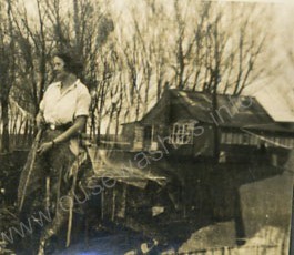 He e-mailed a copy of a faded sepia photograph of a bungalow the family stayed in somewhere on the banks of The Old
Bedford River and wondered whether Peter knew its location, and if it still existed. He didn't, but luckily knew a man who did.
He e-mailed a copy of a faded sepia photograph of a bungalow the family stayed in somewhere on the banks of The Old
Bedford River and wondered whether Peter knew its location, and if it still existed. He didn't, but luckily knew a man who did.What he learned subsequently was how a piece of marshy Cambridgeshire fen farmland just a few miles from his home at Tipps End became world famous as the site in the late 1830s of a great social experiment, a Utopian Dream - The Colony at Manea Fen. Sadly, it didn't last, but some records did and several papers have been published about it. Our task is to tell the story of the Dream and trace and record the changes in the occupants and use of the land in the years since.
Whilst researching, Peter learned of brick-making and pike fishing. Amazingly, he discovered a connection with the Company his father worked for in London in the 1960s, and fabulous British racing cars of the 1950s. He also learned of old railway carriages used as a home, of a glass-bottomed boat, and of a local river frozen hard enough to support a 4x4 jeep. Most astonishingly he learned of a "floating church" serving communities along the Old Bedford River. And much, much more, too.
Background
Social discontent
The events that ultimately led to the establishment of The Colony started 25 years earlier following the end of the Napoleonic Wars in 1815. The economy had been shattered by twenty years or so of war and thousands of ex-soldiers flooded the labour market and the few jobs available were badly paid. Introduction of machinery (particularly agricultural threshing machines) reduced available jobs still further. Living conditions were desperately poor and labourers often resorted to violence to draw attention to their plight. Rioting became commonplace, including the famous Littleport Riots of 1816 and the infamous trial that resulted in five men being hanged, and others deported or jailed, all for relatively minor crimes.Discontent continued for many years and was exacerbated by the introduction of the 1834 amendment to the Poor Laws and the associated workhouses which broke up destitute families by separating men women and children. Public meetings were held against the amendment and many petitions collected. However they were all ignored and the act was implemented. Political or union activity was impossible without the vote or legal sanction for collective bargaining. The Chartist movement was founded demanding universal male suffrage and secret votes, and Methodism flourished because of its concern for social justice whereas the Church of England was seen as part of the ruling establishment, supporting property owners and the rule of law.
Socialism and "The New Moral World"
This was the background to several social experiments - creating community ventures, or communes. The main influence for these communities was the socialist Robert Owen and although his vision of a 'communitarian' society was appealing, he offered little guidance as to how his ideas were to be made reality. All those who began communities in this period faced the central question of what precise purpose a community was to serve, and how it was to contribute to the transition to the 'New Moral World' that the socialist movement wanted.Utopian dream
The idea of The Colony at Manea Fen
Owen's ideals prompted one of his followers, William Hodson, a local farmer and one-time sailor and lay Methodist Minister, living at at what was then Brimstone Hill, now Christchurch, to create his own version of a socialist utopian colony in 1838 on 150-200 acres of his own land at Manea Fen, now known as the Manea Fifties.His plan was to build a little township against the west side of the Old Bedford River at OS grid ref TL 515920 (ie immediately north-east of the lake shown at centre on the 1940s-50s OS map on left ).

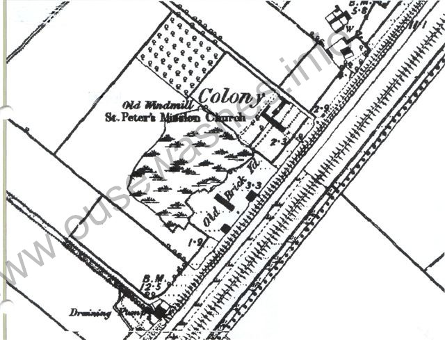
On the right, the 1890 OS Map shows the site in detail (and marks a mission church, St. Peter's, which we have not found mentioned by name anywhere else.)
The Colonists build their Utopian Commune
 The new community needed a mix of trades and it would have taken time to get the right balance. They also had to avoid large families
and others deemed unsuited to the principles of service for the common good, and a trial period had to be introduced before membership
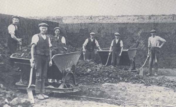
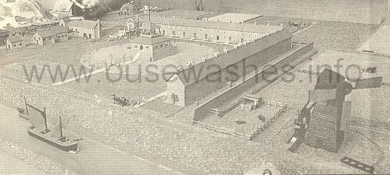
was granted. Initially they would have needed to buy timber or bricks for their housing and workshops, but soon they extracted clay and established a brickyard with kilns just a couple of hundred yards
south from where their township was to be, and connected the two with a railway. We've not found records or drawings of the
clay digging or brickmaking, but the photo on the right from the Sittingbourne Museum website, depicts what it might have looked like.
The new community needed a mix of trades and it would have taken time to get the right balance. They also had to avoid large families
and others deemed unsuited to the principles of service for the common good, and a trial period had to be introduced before membership
was granted. Initially they would have needed to buy timber or bricks for their housing and workshops, but soon they extracted clay and established a brickyard with kilns just a couple of hundred yards
south from where their township was to be, and connected the two with a railway. We've not found records or drawings of the
clay digging or brickmaking, but the photo on the right from the Sittingbourne Museum website, depicts what it might have looked like.The township was to be a large square, with one side open facing the Old Bedford River, and terraces of 8 houses (cottages) on two or maybe all three sides, and a community building in the centre. We know that at least one terrace was completed, possibly two. The houses were heated from a central source, and there was a school, a pavilion, and large windmill. There were shops for grocerys, boot making, etc. and the colonists wore a uniform of Lincoln green designed by Hodson. They installed a printing press and from 20th July 1839 produced a weekly newsletter, ‘The Working Bee’, which was widely distributed. The drawing below is from an 1840 issue; whether an actual representation or what they hoped it would become is debateable.
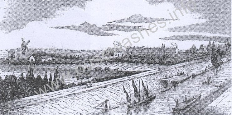
 The sailing vessel in the Old Bedford River is facing downstream, i.e. north-east towards Welney.
The mill is shown north-east of the houses wheras it is south-west in the
1840 drawing.
The sailing vessel in the Old Bedford River is facing downstream, i.e. north-east towards Welney.
The mill is shown north-east of the houses wheras it is south-west in the
1840 drawing.An oddity is the lack of a church on the drawing or in any of the accounts. One would have thought a Methodist Church or Chapel would have been built early in the procedings, especially as Hodson was once a Methodist Minister or lay-preacher. A mission church is marked on the 1890 map, and named (St.Peters), but no other references have been found. to it.
Conflict
This dream didn't last long. There was dissention and conflict within the community. To the committed socialists the Colony was an opportunity in the struggle towards an improved society while others saw it as a refuge and the chance of an easier life. In May 1840 the last two of the 46 editions of the Working Bee had the additional title Herald of the Hodsonian Community Society and the motto "He who will not work neither shall he eat" - a clear message from Hodson to those non-socialists. Another probem was that many who came to this rural idyll were townsfolk (from industrial areas of Northern England and the English Midlands) who did not understand agriculture and needed help from locals who were highly suspicious of this new 'hippie' commune. They also failed to find sufficient markets for their goods - and the site was beset with drainage problems.Utopia no more
Financial backing was inadequate and the scheme eventually collapsed after just a couple of years when Hodson withdrew his support in 1841 after losing money "due to the failure of a local bank" (James Hill's bank, perhaps?). Within a couple of years the colonists had apparently all gone.Ironically there was soon to be a project just a few hundred yards away that would have employed the colonists, made good use of their bricks, and removed the drainage problem too - a steam engine and associated buildings built in 1842 at a cost of £8,000 to replace the inefficient wind drainage mills. If only the Colonists could have hung on another year. There was also a steam engine built at Mepal, just a couple of miles upstream from Manea, in 1840 when the Colony was still in operation - is it possible the Colonists supplied the bricks there? Another works in the area needing vast quantities of bricks just a little later and again easily accessable by boat from the Colony, was the railway built 1844-46. For more information of those please use the navigation menu on left.
There is another page that has a connection with the Colony, and is also about an experiment. The Secretary of the Community in its early days was Samuel Rowbotham, and he believed the Earth was flat, and tried to prove it using the same Old Bedford River that flanked the Colony. Go to "other related pages" on the navigation menu for a link to the Flat Earth Experiments.
The Colonists have gone, but "The Colony" lives on, 1840-1906
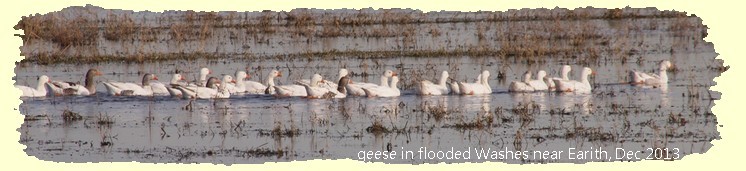
Although the Colonists apparently all left the site in the early 1840s, the houses didn't stay empty for long, and digging clay and making bricks continued for many years. The 1851 census showed 15 houses occupied by 74 people (including, presumably, many children). Eleven men were then involved in brick-making - maybe they had supplied the new pumping station and railway mentioned above ? Thirty years later the population was down to 27, only one of whom was a brick-maker, and only 6 houses occupied. Once clay extraction and brickmaking ceased the pits inevitably filled with water, and are shown on the 1890 map as swamps, and later became a substantial lake covering several acres, more of which later. There were still people living in some of the old houses in the early 1900s. Records show that a baptism took place at The Colony in early 1906, but we believe the houses were all were vacated shortly after, and The Colony finished as a community of one sort or another after 68 years.Tony Smart's boyhood memories
Tony Smart lives in Cambridge but was born and bred in Welney and has had a life-time interest in its history. He recalls:“My Grandfather Bertie was born in one of the Colony Houses in 1899. His family, William and Sabina Smart and offspring were certainly there at the time of the census 1891 (William nick-named "Turkey Billy", one of Turkey Smart's sons). My grandfather was the youngest of the family – they later moved up to Mill Row on the Bedford Bank near Back Drove and in c1915 moved to Brampton Villas on Wisbech Road and remained there - both my father and myself being born there".
"At the time of the 1891 census there were only 8 houses occupied at the Colony along with the Colony farm house. And in these houses there were over 60 people in residence - unbelievably ? From memory the Colony came outside the Welney census and under North Witchford, I think?”
“I was told that the Colony houses were built from the clay excavated from the lakes - my grandfather always referred to them as 'the Pits'."
"During my childhood we would sometimes venture down to the lakes under the pretence of fishing - have a vivid memory of this lakeside residence, single storey villa style and to a child the architecture seemed very foreign, nevertheless could see that someone with money had been living there".
| Year | Occupied Houses | empty houses | People | surnames & size of family | ocupations |
| 1839-40 | colonists | ||||
| 1841 | 19 | all local families - no colonists, according to Lord | agricultural labourers, farm servants | ||
| 1851 | 15 | ? | 74 | 10 brickmakers, 1 brickburner, 10 agr labourers, 1 grocer, | |
| 1861* | n/k | n/k | n/k | Hawes (William & Isabella, & their 7? children incl Sophie, b 1864 at The Colony) | brick maker |
| 1871 | n/k | n/k | n/k | ||
| 1881 | 6 | 2 | 27 | Sisson (1), James (4), Smart (5), Rolfe (1) | 1 brickmaker (Sisson) |
| 1891** | 8 | 63 | Carter (9), Smart (6 and 5), Layford (8), Westfall (6), Carter (9) | ||
| 1901 | n/k | n/k | n/k | ||
| 1906 | |||||
| 1911 | none | none |
** Note, in 1891 there were also 8 Jacksons living at Colony Farm House. Where that was then, we don't know, but nowadays a property with that name is situated some way away, so we've excluded it from this table.
Archaeological Investigations
The site of the Colonists houses has been subject to fieldwork research on several occasions. Most recently by the Cambridge Archaeological Unit (CAU) in the autumn of 2016.An interim report of their investigations and findings is available in PDF format here.
Owners and Occupiers
| from | to | owner(s) | occupier(s) | status/remarks | land use |
| pre 1838 | Hodson, William | farmer | arable | ||
| 1838 | 1841 | The Colonists | |||
| 1841 | 1906 | various local families | farm labourers, brickmakers | ||
| Cambs CC | smallholders | holdings for ex-soldiers | arable | ||
| 1925s? | Vandervell family (trust?) | 8 acre plot with lake & bungalow | |||
| 1925s? | 1967 | Loraine, Lenny | tenant of Vandervell's ? mover to caravan at Three Tuns, Welney |
||
| 1970s | Morehen, Chas & Hilda | owners or managers ? | |||
| 1970s? | 1995 | David, Bob & Hilda | David, Bob & Hilda | Hilda previously married to Morehen. Also owned Pisces |
fishing lake holiday chalet |
| 07/06/1996 | 30/03/2001 | Whitehouse, Bill & wife | Whitehouse, Bill & wife | ||
| 2001 | to date | Crout, Peter & Abigail | Crout, Peter & Abigail | private, but some fishing | |
Notes and sources
| Note | detail/source |
| 1 | |
| 2 |